
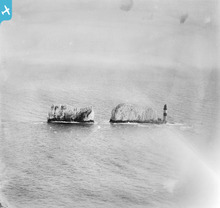
EPW000795 ENGLAND (1920). The Needles Lighthouse and The Needles, Isle of Wight, from the north-west, 1920

© Copyright OpenStreetMap contributors and licensed by the OpenStreetMap Foundation. 2026. Cartography is licensed as CC BY-SA.
Nearby Images (20)
EPW000795

EPW022902

EPW022899

EPW022901

EPW022903

EPW000793

EAW015259

EAW022201

EAW015260

EPW000479

EAW022204

EAW038606

EAW015258

EAW038604

EAW022202

EAW038608

EAW022203

EAW002997

EAW038605

EPW000478

Details
| Title | [EPW000795] The Needles Lighthouse and The Needles, Isle of Wight, from the north-west, 1920 |
| Reference | EPW000795 |
| Date | April-1920 |
| Link | |
| Place name | ISLE OF WIGHT |
| Parish | TOTLAND |
| District | |
| Country | ENGLAND |
| Easting / Northing | 429012, 84888 |
| Longitude / Latitude | -1.589476554387, 50.662360746474 |
| National Grid Reference | SZ290849 |
Pins
Be the first to add a comment to this image!
User Comment Contributions
The Needles. |

Brian Wilkinson |
Friday 25th of May 2012 04:01:42 PM |