
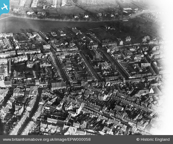
EPW000058 ENGLAND (1920). Newmarket Road, Cambridge, 1920
© Copyright OpenStreetMap contributors and licensed by the OpenStreetMap Foundation. 2026. Cartography is licensed as CC BY-SA.
Nearby Images (2)
EPW000058

EPW000049

Details
| Title | [EPW000058] Newmarket Road, Cambridge, 1920 |
| Reference | EPW000058 |
| Date | January-1920 |
| Link | |
| Place name | CAMBRIDGE |
| Parish | |
| District | |
| Country | ENGLAND |
| Easting / Northing | 545849, 258755 |
| Longitude / Latitude | 0.13471373473697, 52.207289816662 |
| National Grid Reference | TL458588 |
Pins

Geoff D |
Monday 16th of July 2012 11:14:25 AM | |
|
Geoff D |
Monday 16th of July 2012 11:02:31 AM | |
|
rkemp78 |
Wednesday 27th of June 2012 02:29:51 PM | |
|
rkemp78 |
Wednesday 27th of June 2012 02:28:57 PM | |
|
rkemp78 |
Wednesday 27th of June 2012 02:27:59 PM | |
This was Gold Street not Cold Street |
Geoff D |
Monday 16th of July 2012 11:05:27 AM |
|
rkemp78 |
Wednesday 27th of June 2012 02:26:48 PM | |
|
rkemp78 |
Wednesday 27th of June 2012 02:25:44 PM | |
|
rkemp78 |
Wednesday 27th of June 2012 02:25:06 PM |
User Comment Contributions
I grew up near this area and went here a lot I the 1960s it is a pity all these roads have been changed |
john |
Friday 23rd of August 2013 03:54:10 PM |
"Newmarket Road" isn't the best description of this shot. Even in 1920 much of that locality would have been further East. While the start of the road runs across the centre and right hand side of the top of the shot, Fitzroy Street runs across the middle of the shot from side to side. |
Colin Rosenstiel |
Tuesday 26th of June 2012 10:00:27 PM |
Newmarket Road runs across the back of the view, behind Christ Church. The road coming in from bottom left is City Road. The central part of this view is now redeveloped as the Grafton Shopping Centre. |
Quinag |
Tuesday 26th of June 2012 08:18:17 AM |