
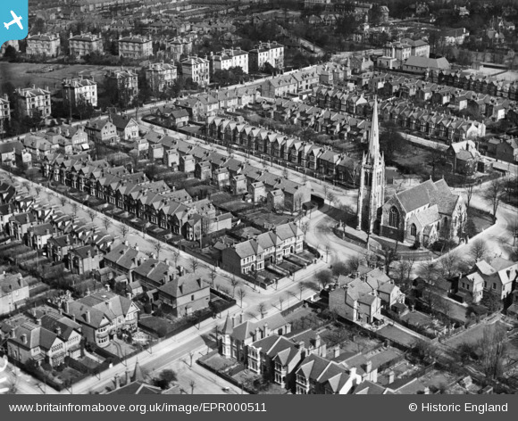
EPR000511 ENGLAND (1935). St Stephen's Church and environs, Ealing, 1935
© Copyright OpenStreetMap contributors and licensed by the OpenStreetMap Foundation. 2026. Cartography is licensed as CC BY-SA.
Nearby Images (2)
EPR000511

EPW010018

Details
| Title | [EPR000511] St Stephen's Church and environs, Ealing, 1935 |
| Reference | EPR000511 |
| Date | 1935 |
| Link | |
| Place name | EALING |
| Parish | |
| District | |
| Country | ENGLAND |
| Easting / Northing | 516684, 181489 |
| Longitude / Latitude | -0.31803944818066, 51.519770856494 |
| National Grid Reference | TQ167815 |
Pins

JaneJ |
Wednesday 29th of April 2020 03:49:56 PM | |
|
JaneJ |
Wednesday 29th of April 2020 03:49:19 PM | |
|
JaneJ |
Wednesday 29th of April 2020 03:47:29 PM | |
|
JaneJ |
Wednesday 29th of April 2020 03:47:15 PM | |
|
JaneJ |
Wednesday 29th of April 2020 03:45:51 PM | |
|
JaneJ |
Wednesday 29th of April 2020 03:45:32 PM | |
|
JaneJ |
Wednesday 29th of April 2020 03:45:17 PM | |
|
JaneJ |
Wednesday 29th of April 2020 03:44:56 PM | |
|
JaneJ |
Wednesday 29th of April 2020 03:44:26 PM | |
|
JaneJ |
Wednesday 29th of April 2020 03:43:54 PM | |
|
JaneJ |
Wednesday 29th of April 2020 03:42:53 PM | |
|
JaneJ |
Wednesday 29th of April 2020 03:42:26 PM | |
|
JaneJ |
Wednesday 29th of April 2020 03:41:40 PM | |
|
JaneJ |
Wednesday 29th of April 2020 03:40:53 PM | |
|
JaneJ |
Wednesday 29th of April 2020 03:40:28 PM | |
|
JaneJ |
Wednesday 29th of April 2020 03:35:13 PM | |
|
JaneJ |
Wednesday 29th of April 2020 03:34:06 PM | |
|
JaneJ |
Wednesday 29th of April 2020 03:33:29 PM |