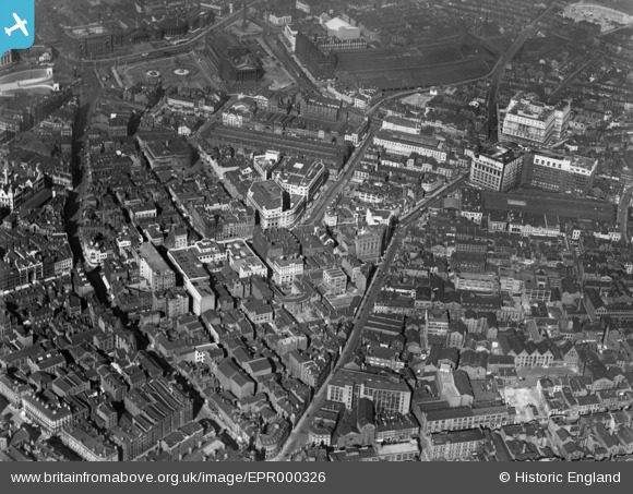
EPR000326 ENGLAND (1934). Hanover Street and environs, Liverpool, 1934
© Copyright OpenStreetMap contributors and licensed by the OpenStreetMap Foundation. 2026. Cartography is licensed as CC BY-SA.
Nearby Images (9)
Details
| Title | [EPR000326] Hanover Street and environs, Liverpool, 1934 |
| Reference | EPR000326 |
| Date | 5-September-1934 |
| Link | |
| Place name | LIVERPOOL |
| Parish | |
| District | |
| Country | ENGLAND |
| Easting / Northing | 334783, 390235 |
| Longitude / Latitude | -2.9810915750235, 53.404639049238 |
| National Grid Reference | SJ348902 |
Pins

ALLEN |
Tuesday 14th of September 2021 10:41:10 PM | |

austin |
Saturday 24th of October 2020 09:04:12 PM | |

austin |
Saturday 24th of October 2020 09:00:33 PM | |

austin |
Saturday 24th of October 2020 08:59:11 PM | |

austin |
Saturday 24th of October 2020 08:58:07 PM | |

austin |
Saturday 24th of October 2020 08:55:10 PM | |

davec |
Sunday 23rd of February 2020 11:29:39 AM | |

davec |
Thursday 23rd of January 2020 02:25:37 PM |


![[EPR000326] Hanover Street and environs, Liverpool, 1934](http://britainfromabove.org.uk/sites/all/libraries/aerofilms-images/public/100x100/EPR/000/EPR000326.jpg)
![[EPW011183] Ranelagh Street and the city, Liverpool, 1924. This image has been produced from a copy-negative.](http://britainfromabove.org.uk/sites/all/libraries/aerofilms-images/public/100x100/EPW/011/EPW011183.jpg)
![[EPW055687] The Cooper & Co Stores Building and Woolworth's Building on Church Street, Liverpool, 1937](http://britainfromabove.org.uk/sites/all/libraries/aerofilms-images/public/100x100/EPW/055/EPW055687.jpg)
![[EPW055685] The Cooper & Co Stores Building and Woolworth's Building on Church Street, Liverpool, 1937](http://britainfromabove.org.uk/sites/all/libraries/aerofilms-images/public/100x100/EPW/055/EPW055685.jpg)
![[EAW001913] Church Street, St John's Market and Central Station, Liverpool, 1946](http://britainfromabove.org.uk/sites/all/libraries/aerofilms-images/public/100x100/EAW/001/EAW001913.jpg)
![[EPW055688] The Cooper & Co Stores Building and Woolworth's Building on Church Street, Liverpool, 1937](http://britainfromabove.org.uk/sites/all/libraries/aerofilms-images/public/100x100/EPW/055/EPW055688.jpg)
![[EPW055684] The Cooper & Co Stores Building and Woolworth's Building on Church Street, Liverpool, 1937](http://britainfromabove.org.uk/sites/all/libraries/aerofilms-images/public/100x100/EPW/055/EPW055684.jpg)
![[EPW055686] The Cooper & Co Stores Building and Woolworth's Building on Church Street, Liverpool, 1937](http://britainfromabove.org.uk/sites/all/libraries/aerofilms-images/public/100x100/EPW/055/EPW055686.jpg)
![[EAW001911] Custom House, Hanover Street and the surrounding bomb damaged area, Liverpool, 1946](http://britainfromabove.org.uk/sites/all/libraries/aerofilms-images/public/100x100/EAW/001/EAW001911.jpg)