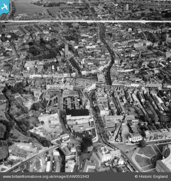
EAW051943 ENGLAND (1953). The town centre, Taunton, 1953. This image was marked by Aerofilms Ltd for photo editing.
© Copyright OpenStreetMap contributors and licensed by the OpenStreetMap Foundation. 2026. Cartography is licensed as CC BY-SA.
Nearby Images (34)
Details
| Title | [EAW051943] The town centre, Taunton, 1953. This image was marked by Aerofilms Ltd for photo editing. |
| Reference | EAW051943 |
| Date | 30-August-1953 |
| Link | |
| Place name | TAUNTON |
| Parish | |
| District | |
| Country | ENGLAND |
| Easting / Northing | 322682, 124514 |
| Longitude / Latitude | -3.1023309314233, 51.014261412198 |
| National Grid Reference | ST227245 |
Pins

Mon |
Saturday 2nd of November 2019 02:36:21 AM | |

Taunton_Lad |
Sunday 2nd of November 2014 02:31:22 AM |


![[EAW051943] The town centre, Taunton, 1953. This image was marked by Aerofilms Ltd for photo editing.](http://britainfromabove.org.uk/sites/all/libraries/aerofilms-images/public/100x100/EAW/051/EAW051943.jpg)
![[EAW005346] The town, Taunton, 1947](http://britainfromabove.org.uk/sites/all/libraries/aerofilms-images/public/100x100/EAW/005/EAW005346.jpg)
![[EAW051947] The town centre, Taunton, 1953. This image was marked by Aerofilms Ltd for photo editing.](http://britainfromabove.org.uk/sites/all/libraries/aerofilms-images/public/100x100/EAW/051/EAW051947.jpg)
![[EPW013541] The Market House, Fore Street and environs, Taunton, 1925. This image has been produced from a copy-negative.](http://britainfromabove.org.uk/sites/all/libraries/aerofilms-images/public/100x100/EPW/013/EPW013541.jpg)
![[EAW005347] The town, Taunton, 1947](http://britainfromabove.org.uk/sites/all/libraries/aerofilms-images/public/100x100/EAW/005/EAW005347.jpg)
![[EPW027886] North Street, the Cattle Market and the town centre, Taunton, 1929. This image has been produced from a copy-negative.](http://britainfromabove.org.uk/sites/all/libraries/aerofilms-images/public/100x100/EPW/027/EPW027886.jpg)
![[EPW041181] Fore Street and the town centre, Taunton, 1933](http://britainfromabove.org.uk/sites/all/libraries/aerofilms-images/public/100x100/EPW/041/EPW041181.jpg)
![[EPW027899] The town centre, Taunton, 1929. This image has been produced from a print.](http://britainfromabove.org.uk/sites/all/libraries/aerofilms-images/public/100x100/EPW/027/EPW027899.jpg)
![[EPW041184] Castle Green and the Castle Hotel, Taunton, 1933](http://britainfromabove.org.uk/sites/all/libraries/aerofilms-images/public/100x100/EPW/041/EPW041184.jpg)
![[EPW041094] North Street and excavation at the Castle Hotel, Taunton, 1933](http://britainfromabove.org.uk/sites/all/libraries/aerofilms-images/public/100x100/EPW/041/EPW041094.jpg)
![[EPW041093] North Street and excavation at the Castle Hotel, Taunton, 1933](http://britainfromabove.org.uk/sites/all/libraries/aerofilms-images/public/100x100/EPW/041/EPW041093.jpg)
![[EPW027893] The town centre, Taunton, 1929. This image has been produced from a print.](http://britainfromabove.org.uk/sites/all/libraries/aerofilms-images/public/100x100/EPW/027/EPW027893.jpg)
![[EPW041183] Castle Green and excavation at the Castle Hotel, Taunton, 1933](http://britainfromabove.org.uk/sites/all/libraries/aerofilms-images/public/100x100/EPW/041/EPW041183.jpg)
![[EAW051944] The town centre, Taunton, 1953](http://britainfromabove.org.uk/sites/all/libraries/aerofilms-images/public/100x100/EAW/051/EAW051944.jpg)
![[EAW005342] The remains of Taunton Castle and environs, Taunton, 1947. This image has been produced from a print.](http://britainfromabove.org.uk/sites/all/libraries/aerofilms-images/public/100x100/EAW/005/EAW005342.jpg)
![[EAW005339] The remains of Taunton Castle and environs, Taunton, 1947. This image has been produced from a print.](http://britainfromabove.org.uk/sites/all/libraries/aerofilms-images/public/100x100/EAW/005/EAW005339.jpg)
![[EPW041182] The Gaumont Palace Cinema and Corporation Street, Taunton, 1933](http://britainfromabove.org.uk/sites/all/libraries/aerofilms-images/public/100x100/EPW/041/EPW041182.jpg)
![[EAW051941] The town centre, Taunton, 1953. This image was marked by Aerofilms Ltd for photo editing.](http://britainfromabove.org.uk/sites/all/libraries/aerofilms-images/public/100x100/EAW/051/EAW051941.jpg)
![[EPW027885] St Mary Magdalen's Church and the town centre, Taunton, 1929. This image has been produced from a copy-negative.](http://britainfromabove.org.uk/sites/all/libraries/aerofilms-images/public/100x100/EPW/027/EPW027885.jpg)
![[EAW005337] The remains of Taunton Castle, Taunton, 1947. This image has been produced from a print.](http://britainfromabove.org.uk/sites/all/libraries/aerofilms-images/public/100x100/EAW/005/EAW005337.jpg)
![[EAW005340] The remains of Taunton Castle, Taunton, 1947](http://britainfromabove.org.uk/sites/all/libraries/aerofilms-images/public/100x100/EAW/005/EAW005340.jpg)
![[EAW005341] The remains of Taunton Castle, Taunton, 1947](http://britainfromabove.org.uk/sites/all/libraries/aerofilms-images/public/100x100/EAW/005/EAW005341.jpg)
![[EAW051946] The town centre, Taunton, 1953](http://britainfromabove.org.uk/sites/all/libraries/aerofilms-images/public/100x100/EAW/051/EAW051946.jpg)
![[EAW051945] The town centre, Taunton, 1953. This image was marked by Aerofilms Ltd for photo editing.](http://britainfromabove.org.uk/sites/all/libraries/aerofilms-images/public/100x100/EAW/051/EAW051945.jpg)
![[EAW005338] The remains of Taunton Castle and environs, Taunton, 1947. This image has been produced from a print.](http://britainfromabove.org.uk/sites/all/libraries/aerofilms-images/public/100x100/EAW/005/EAW005338.jpg)
![[EAW049103] The town centre, Taunton, 1953](http://britainfromabove.org.uk/sites/all/libraries/aerofilms-images/public/100x100/EAW/049/EAW049103.jpg)
![[EAW005343] St Mary Magdalen's Church, Taunton, 1947](http://britainfromabove.org.uk/sites/all/libraries/aerofilms-images/public/100x100/EAW/005/EAW005343.jpg)
![[EAW015036] The town, Taunton, from the south, 1948. This image has been produced from a print.](http://britainfromabove.org.uk/sites/all/libraries/aerofilms-images/public/100x100/EAW/015/EAW015036.jpg)
![[EPW027892] The town centre, Taunton, 1929. This image has been produced from a print.](http://britainfromabove.org.uk/sites/all/libraries/aerofilms-images/public/100x100/EPW/027/EPW027892.jpg)
![[EAW049104] The town centre, Taunton, 1953](http://britainfromabove.org.uk/sites/all/libraries/aerofilms-images/public/100x100/EAW/049/EAW049104.jpg)
![[EPW013539] St Mary Magdalen's Church and East Street, Taunton, 1925. This image has been produced from a print affected by flare.](http://britainfromabove.org.uk/sites/all/libraries/aerofilms-images/public/100x100/EPW/013/EPW013539.jpg)
![[EAW005138] The Shire Hall, County Hall and the High Street, Taunton, 1947](http://britainfromabove.org.uk/sites/all/libraries/aerofilms-images/public/100x100/EAW/005/EAW005138.jpg)
![[EAW005344] The Shire Hall, County Hall and the surrounding area, Taunton, 1947](http://britainfromabove.org.uk/sites/all/libraries/aerofilms-images/public/100x100/EAW/005/EAW005344.jpg)
![[EAW005345] County Hall, the Shire Hall and the Police Station, Taunton, 1947](http://britainfromabove.org.uk/sites/all/libraries/aerofilms-images/public/100x100/EAW/005/EAW005345.jpg)