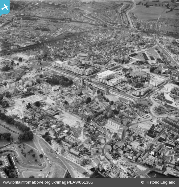
EAW051365 ENGLAND (1953). Royal Parade and the city centre, Plymouth, 1953
© Copyright OpenStreetMap contributors and licensed by the OpenStreetMap Foundation. 2026. Cartography is licensed as CC BY-SA.
Nearby Images (6)
Details
| Title | [EAW051365] Royal Parade and the city centre, Plymouth, 1953 |
| Reference | EAW051365 |
| Date | 11-August-1953 |
| Link | |
| Place name | PLYMOUTH |
| Parish | |
| District | |
| Country | ENGLAND |
| Easting / Northing | 247833, 54383 |
| Longitude / Latitude | -4.139968473616, 50.369032759146 |
| National Grid Reference | SX478544 |


![[EAW051365] Royal Parade and the city centre, Plymouth, 1953](http://britainfromabove.org.uk/sites/all/libraries/aerofilms-images/public/100x100/EAW/051/EAW051365.jpg)
![[EAW007572] The city centre, Plymouth, 1947](http://britainfromabove.org.uk/sites/all/libraries/aerofilms-images/public/100x100/EAW/007/EAW007572.jpg)
![[EPW054888] Sedford Street and environs, Plymouth, 1937](http://britainfromabove.org.uk/sites/all/libraries/aerofilms-images/public/100x100/EPW/054/EPW054888.jpg)
![[EAW051363] Hoe Park and the city centre, Plymouth, 1953](http://britainfromabove.org.uk/sites/all/libraries/aerofilms-images/public/100x100/EAW/051/EAW051363.jpg)
![[EPW054897] Old Town Street and environs, Plymouth, 1937](http://britainfromabove.org.uk/sites/all/libraries/aerofilms-images/public/100x100/EPW/054/EPW054897.jpg)
![[EPW011259] Frankfort Street and environs, Plymouth, 1924. This image has been produced from a copy-negative](http://britainfromabove.org.uk/sites/all/libraries/aerofilms-images/public/100x100/EPW/011/EPW011259.jpg)
