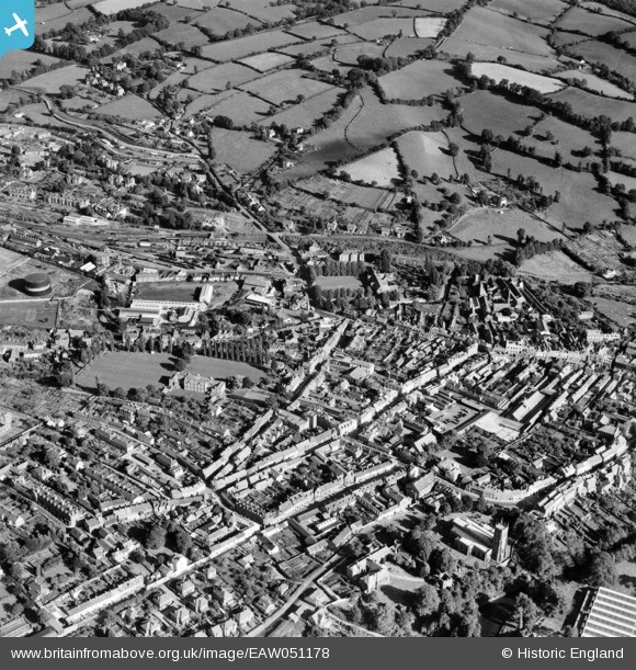
EAW051178 ENGLAND (1953). The town centre, Tiverton, 1953
    © Copyright OpenStreetMap contributors and licensed by the OpenStreetMap Foundation. 2025. Cartography is licensed as CC BY-SA.
  
Details
| Title | [EAW051178] The town centre, Tiverton, 1953 | 
| Reference | EAW051178 | 
| Date | 6-August-1953 | 
| Link | |
| Place name | TIVERTON | 
| Parish | TIVERTON | 
| District | |
| Country | ENGLAND | 
| Easting / Northing | 295770, 112614 | 
| Longitude / Latitude | -3.4824892158755, 50.90302787159 | 
| National Grid Reference | SS958126 | 
Pins
|  Starkey, Knight & Ford Ltd, The Brewery, 37 Fore Street, Tiverton. The brewery was founded in 1852 by Thomas Ford & was taken over in 1895 by Starkey, Knight to form Starkey, Knight & Ford. The company was taken over by Whitbread & Co Ltd and the Tiverton brewery finally closed in 1982.Now demolished. |   Stu Giles | Wednesday 27th of June 2018 04:50:38 PM | 
 
             
  ![[EAW051178] The town centre, Tiverton, 1953](http://britainfromabove.org.uk/sites/all/libraries/aerofilms-images/public/100x100/EAW/051/EAW051178.jpg) 
  
                                          ![[EPW024000] Gold Street and environs, Tiverton, 1928](http://britainfromabove.org.uk/sites/all/libraries/aerofilms-images/public/100x100/EPW/024/EPW024000.jpg) 
 ![[EAW051180] The town centre, Tiverton, 1953](http://britainfromabove.org.uk/sites/all/libraries/aerofilms-images/public/100x100/EAW/051/EAW051180.jpg) 
 ![[EAW051179] The town centre, Tiverton, 1953](http://britainfromabove.org.uk/sites/all/libraries/aerofilms-images/public/100x100/EAW/051/EAW051179.jpg)