
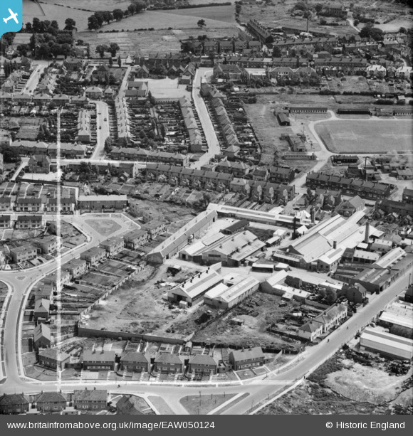
EAW050124 ENGLAND (1953). The Sandwell Casting Co Ltd Bank Street Foundry, Hateley Heath, 1953. This image was marked by Aerofilms Ltd for photo editing.
© Copyright OpenStreetMap contributors and licensed by the OpenStreetMap Foundation. 2026. Cartography is licensed as CC BY-SA.
Nearby Images (9)
EAW050124

 0°
0m
0°
0m
EAW050120
 319°
45m
319°
45m
EAW050118
 278°
78m
278°
78m
EAW050119
 256°
82m
256°
82m
EAW050123
 278°
87m
278°
87m
EAW050126
 326°
101m
326°
101m
EAW050122
 308°
125m
308°
125m
EAW050125
 324°
131m
324°
131m
EAW050121
 274°
147m
274°
147m
Details
| Title | [EAW050124] The Sandwell Casting Co Ltd Bank Street Foundry, Hateley Heath, 1953. This image was marked by Aerofilms Ltd for photo editing. |
| Reference | EAW050124 |
| Date | 26-June-1953 |
| Link | |
| Place name | HATELEY HEATH |
| Parish | |
| District | |
| Country | ENGLAND |
| Easting / Northing | 400662, 292845 |
| Longitude / Latitude | -1.99023966501, 52.533107154276 |
| National Grid Reference | SP007928 |
Pins
 Churchfield House. Not to be confused with Churchfield Farm, which is out of shot in this photo, The latter lay further North East from Churchfield House. Churchfield House. Not to be confused with Churchfield Farm, which is out of shot in this photo, The latter lay further North East from Churchfield House. |

DaveT |
Wednesday 27th of May 2026 09:15:10 AM |
| Hall End Tavern |
H |
Tuesday 7th of February 2023 05:22:24 PM |
| All Saints School |
H |
Tuesday 7th of February 2023 05:21:58 PM |
| The Red Lion Public House |
H |
Tuesday 7th of February 2023 05:21:26 PM |
| Arlington Road |
H |
Tuesday 7th of February 2023 05:20:28 PM |
| Connor Hall
|
H |
Sunday 9th of February 2020 06:03:32 PM |
| The Ring o'Bells public house, where they sold beer by the Pound (for stray animals); can be seen in front of the pub. |
DaveT |
Wednesday 25th of June 2014 04:09:57 PM |