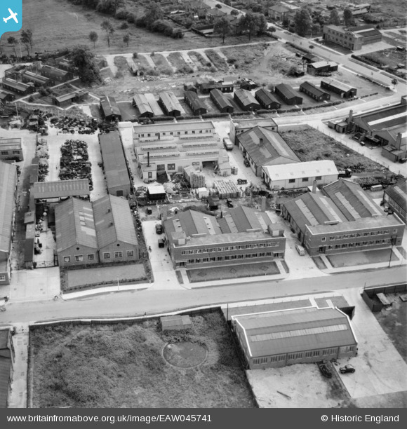
EAW045741 ENGLAND (1952). Factories on Chester Road, Borehamwood, 1952
© Copyright OpenStreetMap contributors and licensed by the OpenStreetMap Foundation. 2026. Cartography is licensed as CC BY-SA.
Nearby Images (44)
Details
| Title | [EAW045741] Factories on Chester Road, Borehamwood, 1952 |
| Reference | EAW045741 |
| Date | 6-August-1952 |
| Link | |
| Place name | BOREHAMWOOD |
| Parish | ELSTREE AND BOREHAMWOOD |
| District | |
| Country | ENGLAND |
| Easting / Northing | 520510, 196839 |
| Longitude / Latitude | -0.25764454805156, 51.65693660051 |
| National Grid Reference | TQ205968 |
Pins

Billy Turner |
Friday 9th of December 2016 07:02:56 PM | |

Billy Turner |
Friday 9th of December 2016 06:54:43 PM |


![[EAW045741] Factories on Chester Road, Borehamwood, 1952](http://britainfromabove.org.uk/sites/all/libraries/aerofilms-images/public/100x100/EAW/045/EAW045741.jpg)
![[EAW044310] The Henderson Safety Tank Co Ltd on Chester Road, Borehamwood, 1952](http://britainfromabove.org.uk/sites/all/libraries/aerofilms-images/public/100x100/EAW/044/EAW044310.jpg)
![[EAW045739] Factories on Chester Road, Borehamwood, 1952](http://britainfromabove.org.uk/sites/all/libraries/aerofilms-images/public/100x100/EAW/045/EAW045739.jpg)
![[EPW057941] Elstree Way and the Barnet By-Pass (A1) under construction, Borehamwood, from the west, 1938](http://britainfromabove.org.uk/sites/all/libraries/aerofilms-images/public/100x100/EPW/057/EPW057941.jpg)
![[EAW045742] Factories and depot between Chester Road and King George's Field, Borehamwood, 1952](http://britainfromabove.org.uk/sites/all/libraries/aerofilms-images/public/100x100/EAW/045/EAW045742.jpg)
![[EAW031641] John Laing and Son Ltd Depot off Chester Road, Borehamwood, 1950](http://britainfromabove.org.uk/sites/all/libraries/aerofilms-images/public/100x100/EAW/031/EAW031641.jpg)
![[EAW045740] Factories and depot between Chester Road and King George's Field, Borehamwood, 1952](http://britainfromabove.org.uk/sites/all/libraries/aerofilms-images/public/100x100/EAW/045/EAW045740.jpg)
![[EAW031635] John Laing and Son Ltd Depot off Chester Road, Borehamwood, 1950](http://britainfromabove.org.uk/sites/all/libraries/aerofilms-images/public/100x100/EAW/031/EAW031635.jpg)
![[EAW031637] John Laing and Son Ltd Depot off Chester Road and environs, Borehamwood, 1950](http://britainfromabove.org.uk/sites/all/libraries/aerofilms-images/public/100x100/EAW/031/EAW031637.jpg)
![[EAW012435] Aerofilms Ltd offices at 6 Elstree Way and environs, Borehamwood, 1947](http://britainfromabove.org.uk/sites/all/libraries/aerofilms-images/public/100x100/EAW/012/EAW012435.jpg)
![[EAW031639] John Laing and Son Ltd Depot off Chester Road, Borehamwood, 1950](http://britainfromabove.org.uk/sites/all/libraries/aerofilms-images/public/100x100/EAW/031/EAW031639.jpg)
![[EAW012434] Aerofilms Ltd offices at 6 Elstree Way and environs, Borehamwood, 1947](http://britainfromabove.org.uk/sites/all/libraries/aerofilms-images/public/100x100/EAW/012/EAW012434.jpg)
![[EAW012442] Aerofilms Ltd offices at 6 Elstree Way, Borehamwood, 1947](http://britainfromabove.org.uk/sites/all/libraries/aerofilms-images/public/100x100/EAW/012/EAW012442.jpg)
![[EAW043031] Hunting Aerosurveys Ltd Offices at 6 Elstree Way, Borehamwood, 1952](http://britainfromabove.org.uk/sites/all/libraries/aerofilms-images/public/100x100/EAW/043/EAW043031.jpg)
![[EAW043028] Hunting Aerosurveys Ltd Offices at 6 Elstree Way, Borehamwood, 1952](http://britainfromabove.org.uk/sites/all/libraries/aerofilms-images/public/100x100/EAW/043/EAW043028.jpg)
![[EAW043029] Hunting Aerosurveys Ltd Offices at 6 Elstree Way, Borehamwood, 1952](http://britainfromabove.org.uk/sites/all/libraries/aerofilms-images/public/100x100/EAW/043/EAW043029.jpg)
![[EAW023316] The MGM British Film Studios and factories on Elstree Way and Manor Way, Borehamwood, 1949](http://britainfromabove.org.uk/sites/all/libraries/aerofilms-images/public/100x100/EAW/023/EAW023316.jpg)
![[EAW044448] Industrial premises on Elstree Way, Borehamwood, 1952](http://britainfromabove.org.uk/sites/all/libraries/aerofilms-images/public/100x100/EAW/044/EAW044448.jpg)
![[EAW044449] Industrial premises on Elstree Way, Borehamwood, 1952](http://britainfromabove.org.uk/sites/all/libraries/aerofilms-images/public/100x100/EAW/044/EAW044449.jpg)
![[EAW011794] Huntings Surveys Limited, Borehamwood, 1947](http://britainfromabove.org.uk/sites/all/libraries/aerofilms-images/public/100x100/EAW/011/EAW011794.jpg)
![[EAW043032] Hunting Aerosurveys Ltd Offices at 6 Elstree Way, Borehamwood, 1952](http://britainfromabove.org.uk/sites/all/libraries/aerofilms-images/public/100x100/EAW/043/EAW043032.jpg)
![[EAW043027] Hunting Aerosurveys Ltd Offices at 6 Elstree Way, Borehamwood, 1952](http://britainfromabove.org.uk/sites/all/libraries/aerofilms-images/public/100x100/EAW/043/EAW043027.jpg)
![[EAW044451] Industrial premises on Elstree Way, Borehamwood, 1952](http://britainfromabove.org.uk/sites/all/libraries/aerofilms-images/public/100x100/EAW/044/EAW044451.jpg)
![[EAW012439] Aerofilms Ltd offices at 6 Elstree Way, Borehamwood, 1947. This image has been produced from a damaged negative.](http://britainfromabove.org.uk/sites/all/libraries/aerofilms-images/public/100x100/EAW/012/EAW012439.jpg)
![[EAW013430] An experimental colour image of the MGM Film Studios on Elstree Way, Borehamwood, from the south, 1948](http://britainfromabove.org.uk/sites/all/libraries/aerofilms-images/public/100x100/EAW/013/EAW013430.jpg)
![[EAW043030] Hunting Aerosurveys Ltd Offices at 6 Elstree Way, Borehamwood, 1952](http://britainfromabove.org.uk/sites/all/libraries/aerofilms-images/public/100x100/EAW/043/EAW043030.jpg)
![[EAW044441] Industrial premises on Elstree Way, Borehamwood, 1952](http://britainfromabove.org.uk/sites/all/libraries/aerofilms-images/public/100x100/EAW/044/EAW044441.jpg)
![[EAW012436] Aerofilms Ltd offices at 6 Elstree Way, Borehamwood, 1947](http://britainfromabove.org.uk/sites/all/libraries/aerofilms-images/public/100x100/EAW/012/EAW012436.jpg)
![[EAW012437] Aerofilms Ltd offices at 6 Elstree Way, Borehamwood, 1947](http://britainfromabove.org.uk/sites/all/libraries/aerofilms-images/public/100x100/EAW/012/EAW012437.jpg)
![[EAW011795] Huntings Surveys Limited, Borehamwood, 1947](http://britainfromabove.org.uk/sites/all/libraries/aerofilms-images/public/100x100/EAW/011/EAW011795.jpg)
![[EAW023306] The MGM British Film Studios on Elstree Way, Borehamwood, from the south-west, 1949](http://britainfromabove.org.uk/sites/all/libraries/aerofilms-images/public/100x100/EAW/023/EAW023306.jpg)
![[EAW031643] John Laing and Son Ltd Depot off Chester Road, Borehamwood, 1950](http://britainfromabove.org.uk/sites/all/libraries/aerofilms-images/public/100x100/EAW/031/EAW031643.jpg)
![[EAW044306] New housing under construction to the south of Elstree Way, Borehamwood, from the north, 1952](http://britainfromabove.org.uk/sites/all/libraries/aerofilms-images/public/100x100/EAW/044/EAW044306.jpg)
![[EAW012441] Aerofilms Ltd offices at 6 Elstree Way, Borehamwood, 1947](http://britainfromabove.org.uk/sites/all/libraries/aerofilms-images/public/100x100/EAW/012/EAW012441.jpg)
![[EAW031638] John Laing and Son Ltd Depot off Chester Road, Borehamwood, 1950](http://britainfromabove.org.uk/sites/all/libraries/aerofilms-images/public/100x100/EAW/031/EAW031638.jpg)
![[EAW012440] Aerofilms Ltd offices at 6 Elstree Way opposite the MGM Studios, Borehamwood, 1947](http://britainfromabove.org.uk/sites/all/libraries/aerofilms-images/public/100x100/EAW/012/EAW012440.jpg)
![[EAW031634] John Laing and Son Ltd Depot off Chester Road, Borehamwood, 1950](http://britainfromabove.org.uk/sites/all/libraries/aerofilms-images/public/100x100/EAW/031/EAW031634.jpg)
![[EAW031644] John Laing and Son Ltd Depot off Chester Road and environs, Borehamwood, from the north-east, 1950](http://britainfromabove.org.uk/sites/all/libraries/aerofilms-images/public/100x100/EAW/031/EAW031644.jpg)
![[EAW033381] The area between Elstree Way, Furzehill Road and the Barnet Bypass under development, Borehamwood, 1950.](http://britainfromabove.org.uk/sites/all/libraries/aerofilms-images/public/100x100/EAW/033/EAW033381.jpg)
![[EAW012438] Aerofilms Ltd offices at 6 Elstree Way, Borehamwood, 1947](http://britainfromabove.org.uk/sites/all/libraries/aerofilms-images/public/100x100/EAW/012/EAW012438.jpg)
![[EAW031633] John Laing and Son Ltd Depot off Chester Road, Borehamwood, 1950](http://britainfromabove.org.uk/sites/all/libraries/aerofilms-images/public/100x100/EAW/031/EAW031633.jpg)
![[EAW031640] John Laing and Son Ltd Depot off Chester Road and Featherstone Gardens, Borehamwood, 1950](http://britainfromabove.org.uk/sites/all/libraries/aerofilms-images/public/100x100/EAW/031/EAW031640.jpg)
![[EAW031636] John Laing and Son Ltd Depot off Chester Road, Borehamwood, 1950](http://britainfromabove.org.uk/sites/all/libraries/aerofilms-images/public/100x100/EAW/031/EAW031636.jpg)
![[EAW044450] Industrial premises on Elstree Way, Borehamwood, 1952](http://britainfromabove.org.uk/sites/all/libraries/aerofilms-images/public/100x100/EAW/044/EAW044450.jpg)

