
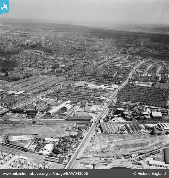
EAW043555 ENGLAND (1952). Lea Bridge Station, Lea Bridge Road and environs, Leyton, from the south-west, 1952
© Copyright OpenStreetMap contributors and licensed by the OpenStreetMap Foundation. 2026. Cartography is licensed as CC BY-SA.
Nearby Images (9)
EAW043555

EAW004127

EAW004124

EAW004123

EAW004126

EAW004125

EAW004121

EAW004122

EPW042089

Details
| Title | [EAW043555] Lea Bridge Station, Lea Bridge Road and environs, Leyton, from the south-west, 1952 |
| Reference | EAW043555 |
| Date | 4-June-1952 |
| Link | |
| Place name | LEYTON |
| Parish | |
| District | |
| Country | ENGLAND |
| Easting / Northing | 536208, 187141 |
| Longitude / Latitude | -0.034584865015014, 51.566195123772 |
| National Grid Reference | TQ362871 |
Pins

Dank |
Sunday 11th of February 2024 09:01:46 PM | |
|
Dank |
Sunday 11th of February 2024 09:00:38 PM | |
|
Leslie B |
Wednesday 26th of October 2022 02:56:30 PM | |
|
Post-war prefabs |
Wednesday 20th of November 2019 11:02:07 AM | |
|
John Wass |
Saturday 4th of July 2015 03:20:38 PM | |
|
gerry-r |
Sunday 15th of June 2014 09:11:24 PM |