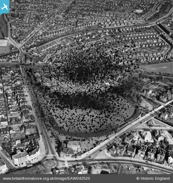
EAW042520 ENGLAND (1952). Trent Bridge Cricket Ground, West Bridgford, 1952. This image has been produced from a damaged negative.
© Copyright OpenStreetMap contributors and licensed by the OpenStreetMap Foundation. 2026. Cartography is licensed as CC BY-SA.
Nearby Images (8)
Details
| Title | [EAW042520] Trent Bridge Cricket Ground, West Bridgford, 1952. This image has been produced from a damaged negative. |
| Reference | EAW042520 |
| Date | 17-April-1952 |
| Link | |
| Place name | WEST BRIDGFORD |
| Parish | |
| District | |
| Country | ENGLAND |
| Easting / Northing | 458513, 338085 |
| Longitude / Latitude | -1.12928868545, 52.936653395979 |
| National Grid Reference | SK585381 |
Pins
Be the first to add a comment to this image!


![[EAW042520] Trent Bridge Cricket Ground, West Bridgford, 1952. This image has been produced from a damaged negative.](http://britainfromabove.org.uk/sites/all/libraries/aerofilms-images/public/100x100/EAW/042/EAW042520.jpg)
![[EAW050482] County Hall and Trent Bridge Cricket Ground, West Bridgford, 1953](http://britainfromabove.org.uk/sites/all/libraries/aerofilms-images/public/100x100/EAW/050/EAW050482.jpg)
![[EPW021044] Trent Bridge Cricket Ground, West Bridgford, 1928](http://britainfromabove.org.uk/sites/all/libraries/aerofilms-images/public/100x100/EPW/021/EPW021044.jpg)
![[EPW021045] Trent Bridge Cricket Ground, West Bridgford, 1928](http://britainfromabove.org.uk/sites/all/libraries/aerofilms-images/public/100x100/EPW/021/EPW021045.jpg)
![[EPR000148] Trent Bridge Cricket Ground, West Bridgford, 1934](http://britainfromabove.org.uk/sites/all/libraries/aerofilms-images/public/100x100/EPR/000/EPR000148.jpg)
![[EAW050483] Trent Bridge Cricket Ground and environs, West Bridgford, 1953](http://britainfromabove.org.uk/sites/all/libraries/aerofilms-images/public/100x100/EAW/050/EAW050483.jpg)
![[EAW042519] Trent Bridge Cricket Ground, West Bridgford, 1952](http://britainfromabove.org.uk/sites/all/libraries/aerofilms-images/public/100x100/EAW/042/EAW042519.jpg)
![[EPR000153] Trent Bridge Cricket Ground and envions, West Bridgford, 1934](http://britainfromabove.org.uk/sites/all/libraries/aerofilms-images/public/100x100/EPR/000/EPR000153.jpg)