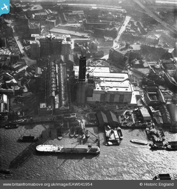
EAW041954 ENGLAND (1952). Bankside Power Station under construction, The Borough, 1952
    © Copyright OpenStreetMap contributors and licensed by the OpenStreetMap Foundation. 2025. Cartography is licensed as CC BY-SA.
  
Nearby Images (17)
Details
| Title | [EAW041954] Bankside Power Station under construction, The Borough, 1952 | 
| Reference | EAW041954 | 
| Date | 14-March-1952 | 
| Link | |
| Place name | THE BOROUGH | 
| Parish | |
| District | |
| Country | ENGLAND | 
| Easting / Northing | 531987, 180482 | 
| Longitude / Latitude | -0.097952162633147, 51.507351411937 | 
| National Grid Reference | TQ320805 | 
Pins
|   Alan McFaden | Saturday 9th of August 2014 06:13:31 PM | |
|   Alan McFaden | Wednesday 14th of May 2014 09:26:42 AM | |
|   Alan McFaden | Wednesday 14th of May 2014 09:26:05 AM | |
|   Alan McFaden | Wednesday 14th of May 2014 09:23:43 AM | |
|   Alan McFaden | Wednesday 14th of May 2014 09:22:20 AM | 
User Comment Contributions
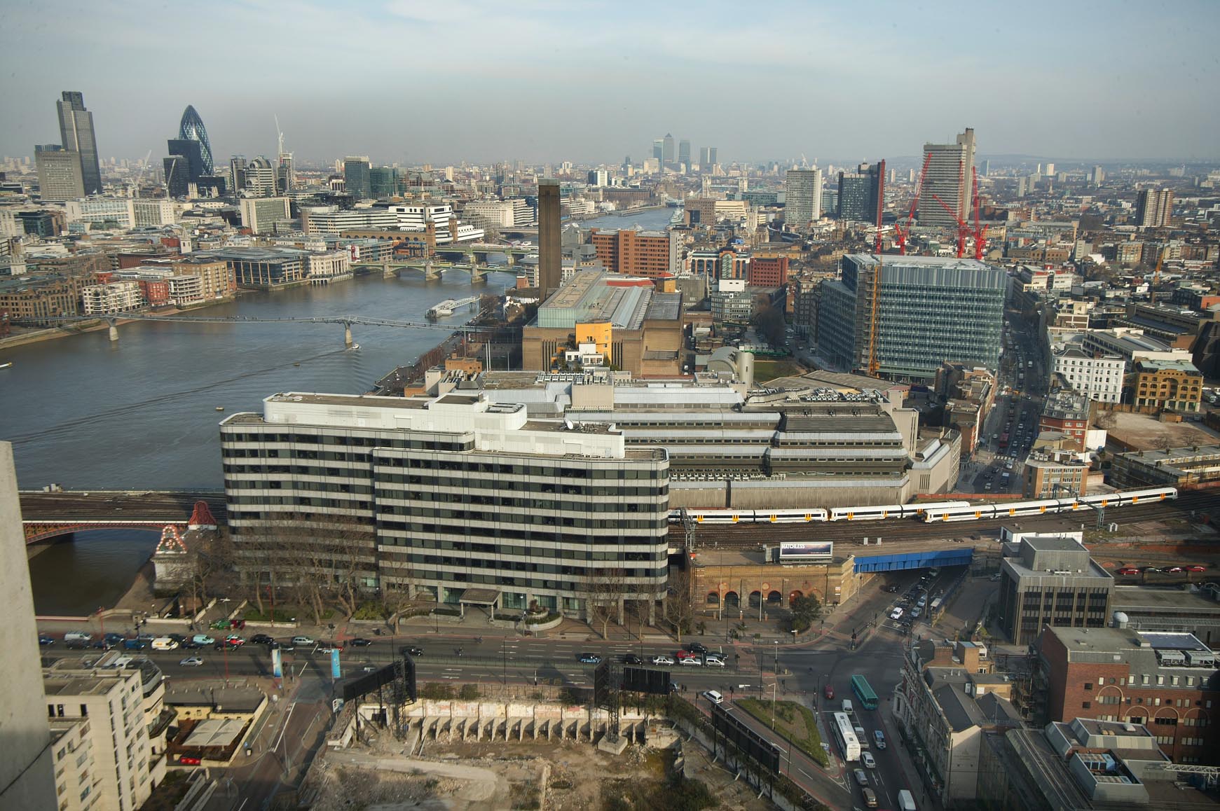
|   Bankside Area from the Kings Reach Tower 2006 |   Alan McFaden | Saturday 9th of August 2014 06:08:46 PM | 
| Bankside Power Station now Tate Modern from St. Paul's Cathedral looking south 07/01/2008 | Class31 | Tuesday 13th of May 2014 08:31:24 AM | 
 
             
  ![[EAW041954] Bankside Power Station under construction, The Borough, 1952](http://britainfromabove.org.uk/sites/all/libraries/aerofilms-images/public/100x100/EAW/041/EAW041954.jpg) 
  
                                          ![[EAW041952] Bankside Power Station under construction, The Borough, 1952](http://britainfromabove.org.uk/sites/all/libraries/aerofilms-images/public/100x100/EAW/041/EAW041952.jpg) 
 ![[EAW041951] Bankside Power Station under construction, The Borough, 1952](http://britainfromabove.org.uk/sites/all/libraries/aerofilms-images/public/100x100/EAW/041/EAW041951.jpg) 
 ![[EAW041955] Bankside Power Station under construction, The Borough, 1952](http://britainfromabove.org.uk/sites/all/libraries/aerofilms-images/public/100x100/EAW/041/EAW041955.jpg) 
 ![[EAW043633] Bankside Power Station under construction and the surrounding area, The Borough, 1952](http://britainfromabove.org.uk/sites/all/libraries/aerofilms-images/public/100x100/EAW/043/EAW043633.jpg) 
 ![[EAW043634] Bankside Power Station under construction and Blackfriars Bridge, The Borough, 1952](http://britainfromabove.org.uk/sites/all/libraries/aerofilms-images/public/100x100/EAW/043/EAW043634.jpg) 
 ![[EAW041953] Bankside Power Station under construction, The Borough, 1952](http://britainfromabove.org.uk/sites/all/libraries/aerofilms-images/public/100x100/EAW/041/EAW041953.jpg) 
 ![[EAW043632] Bankside Power Station under construction and Blackfriars Bridge, The Borough, 1952](http://britainfromabove.org.uk/sites/all/libraries/aerofilms-images/public/100x100/EAW/043/EAW043632.jpg) 
 ![[EAW000519] Blackfriars Bridge and Station and the city, The Borough, from the south-east, 1946](http://britainfromabove.org.uk/sites/all/libraries/aerofilms-images/public/100x100/EAW/000/EAW000519.jpg) 
 ![[EAW028772] Bankside Power Station under construction and environs, The Borough, 1950. This image was marked by Aerofilms Ltd for photo editing.](http://britainfromabove.org.uk/sites/all/libraries/aerofilms-images/public/100x100/EAW/028/EAW028772.jpg) 
 ![[EAW028770] Southwark Street, Bankside Power Station under construction and environs, The Borough, 1950. This image was marked by Aerofilms Ltd for photo editing.](http://britainfromabove.org.uk/sites/all/libraries/aerofilms-images/public/100x100/EAW/028/EAW028770.jpg) 
 ![[EAW043631] Bankside Power Station under construction and the surrounding area, The Borough, 1952](http://britainfromabove.org.uk/sites/all/libraries/aerofilms-images/public/100x100/EAW/043/EAW043631.jpg) 
 ![[EAW028768] The area around Southwark Street between Blackfriars Road and Southwark Bridge Road, The Borough, 1950. This image was marked by Aerofilms Ltd for photo editing.](http://britainfromabove.org.uk/sites/all/libraries/aerofilms-images/public/100x100/EAW/028/EAW028768.jpg) 
 ![[EAW028765] Suffolk Street, Sumner Street and environs, The Borough, 1950. This image was marked by Aerofilms Ltd for photo editing.](http://britainfromabove.org.uk/sites/all/libraries/aerofilms-images/public/100x100/EAW/028/EAW028765.jpg) 
 ![[EAW028764] Southwark Street from Great Guildford Street to Hopton Street, The Borough, 1950. This image was marked by Aerofilms Ltd for photo editing.](http://britainfromabove.org.uk/sites/all/libraries/aerofilms-images/public/100x100/EAW/028/EAW028764.jpg) 
 ![[EAW028771] Southwark Street, Blackfriars Bridge and environs, The Borough, 1950. This image was marked by Aerofilms Ltd for photo editing.](http://britainfromabove.org.uk/sites/all/libraries/aerofilms-images/public/100x100/EAW/028/EAW028771.jpg) 
 ![[EPW005135] Blackfriars Bridge, London, 1920](http://britainfromabove.org.uk/sites/all/libraries/aerofilms-images/public/100x100/EPW/005/EPW005135.jpg) 
 
 Great Guildford Street
 Great Guildford Street


