
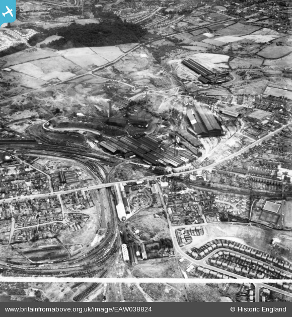
EAW038824 ENGLAND (1951). Round Oak Iron and Steel Works, Brierley Hill, 1951. This image has been produced from a print marked by Aerofilms Ltd for photo editing.
© Copyright OpenStreetMap contributors and licensed by the OpenStreetMap Foundation. 2026. Cartography is licensed as CC BY-SA.
Nearby Images (27)
EAW038824

EAW008343

EAW038832

EAW038830

EAW038831

EAW008339

EAW008338

EAW008344

EAW008342

EAW008349

EAW038833

EAW008351

EAW008350

EAW038834

EAW038825

EAW038836

EAW008340

EAW008347

EAW008348

EAW008345

EAW038837

EAW008346

EAW008341

EAW038844

EAW038827

EAW038835

EAW038842

Details
| Title | [EAW038824] Round Oak Iron and Steel Works, Brierley Hill, 1951. This image has been produced from a print marked by Aerofilms Ltd for photo editing. |
| Reference | EAW038824 |
| Date | 15-August-1951 |
| Link | |
| Place name | BRIERLEY HILL |
| Parish | |
| District | |
| Country | ENGLAND |
| Easting / Northing | 392112, 287790 |
| Longitude / Latitude | -2.1161783326536, 52.487601211858 |
| National Grid Reference | SO921878 |
Pins

Terry lane |
Wednesday 12th of November 2025 06:21:53 PM | |
|
Terry lane |
Wednesday 12th of November 2025 06:20:56 PM | |
|
Peter Turvey |
Sunday 23rd of November 2014 10:53:36 PM |