
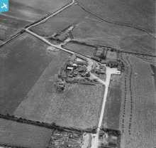
EAW031894 ENGLAND (1950). Abbey Farm and the ruins of St Andrew's Priory, Broomholm, 1950

© Copyright OpenStreetMap contributors and licensed by the OpenStreetMap Foundation. 2026. Cartography is licensed as CC BY-SA.
Nearby Images (4)
EAW031894

EAW031896

EAW031897

EAW031895

Details
| Title | [EAW031894] Abbey Farm and the ruins of St Andrew's Priory, Broomholm, 1950 |
| Reference | EAW031894 |
| Date | 14-August-1950 |
| Link | |
| Place name | BROOMHOLM |
| Parish | BACTON |
| District | |
| Country | ENGLAND |
| Easting / Northing | 634728, 333238 |
| Longitude / Latitude | 1.4860950913299, 52.845072208318 |
| National Grid Reference | TG347332 |
Pins
User Comment Contributions
Pillboxes at Broomholme. |

cptpies |
Tuesday 20th of May 2014 12:59:50 PM |