
EAW029856 ENGLAND (1950). Scafell Pike, Sca Fell, 1950

© Copyright OpenStreetMap contributors and licensed by the OpenStreetMap Foundation. 2026. Cartography is licensed as CC BY-SA.
Details
| Title | [EAW029856] Scafell Pike, Sca Fell, 1950 |
| Reference | EAW029856 |
| Date | 24-May-1950 |
| Link | |
| Place name | SCA FELL |
| Parish | ESKDALE |
| District | |
| Country | ENGLAND |
| Easting / Northing | 321354, 506983 |
| Longitude / Latitude | -3.2131194520622, 54.452005833314 |
| National Grid Reference | NY214070 |
Pins

User Comment Contributions

Although only a simple slab & not visible in this photo, it is the highest memorial in England and probably Britain. |

melgibbs |
Friday 20th of March 2015 06:58:33 AM |
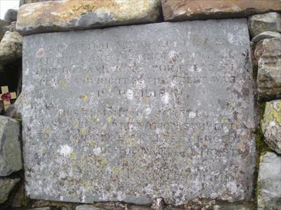
Although not visible in this photo, on the summit is a cairn with a WW1 war memorial to the men of the Lake District donated by Baron Leconfield in 1919. For more details on the memorial, see www.iwm.org.uk/memorials/item/memorial/3962. |
melgibbs |
Thursday 19th of March 2015 12:10:14 PM |