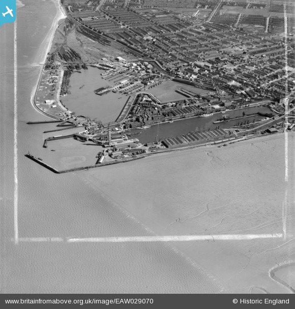
EAW029070 ENGLAND (1950). The Royal Dock, Tidal Basin and Fish Docks, Grimsby, 1950. This image was marked by Aerofilms Ltd for photo editing.
© Copyright OpenStreetMap contributors and licensed by the OpenStreetMap Foundation. 2026. Cartography is licensed as CC BY-SA.
Nearby Images (17)
Details
| Title | [EAW029070] The Royal Dock, Tidal Basin and Fish Docks, Grimsby, 1950. This image was marked by Aerofilms Ltd for photo editing. |
| Reference | EAW029070 |
| Date | 10-May-1950 |
| Link | |
| Place name | GRIMSBY |
| Parish | |
| District | |
| Country | ENGLAND |
| Easting / Northing | 527719, 411266 |
| Longitude / Latitude | -0.070538676820259, 53.582167680758 |
| National Grid Reference | TA277113 |


![[EAW029070] The Royal Dock, Tidal Basin and Fish Docks, Grimsby, 1950. This image was marked by Aerofilms Ltd for photo editing.](http://britainfromabove.org.uk/sites/all/libraries/aerofilms-images/public/100x100/EAW/029/EAW029070.jpg)
![[EAW029071] The Royal Dock, Tidal Basin and Fish Docks, Grimsby, 1950. This image was marked by Aerofilms Ltd for photo editing.](http://britainfromabove.org.uk/sites/all/libraries/aerofilms-images/public/100x100/EAW/029/EAW029071.jpg)
![[EAW029078] The Tidal Basin, Royal Dock and Fish Docks, Grimsby, 1950. This image was marked by Aerofilms Ltd for photo editing.](http://britainfromabove.org.uk/sites/all/libraries/aerofilms-images/public/100x100/EAW/029/EAW029078.jpg)
![[EAW029016] The Royal Dock and Tidal Basin, Grimsby, 1950. This image was marked by Aerofilms Ltd for photo editing.](http://britainfromabove.org.uk/sites/all/libraries/aerofilms-images/public/100x100/EAW/029/EAW029016.jpg)
![[EAW029013] The Royal Dock and Tidal Basin, Grimsby, 1950. This image was marked by Aerofilms Ltd for photo editing.](http://britainfromabove.org.uk/sites/all/libraries/aerofilms-images/public/100x100/EAW/029/EAW029013.jpg)
![[EAW029405] The Docks, Grimsby, 1950](http://britainfromabove.org.uk/sites/all/libraries/aerofilms-images/public/100x100/EAW/029/EAW029405.jpg)
![[EAW029073] The Royal Dock and Tidal Basin, Grimsby, 1950. This image was marked by Aerofilms Ltd for photo editing.](http://britainfromabove.org.uk/sites/all/libraries/aerofilms-images/public/100x100/EAW/029/EAW029073.jpg)
![[EPW012668] The Dock Tower, Grimsby, 1925](http://britainfromabove.org.uk/sites/all/libraries/aerofilms-images/public/100x100/EPW/012/EPW012668.jpg)
![[EPW053397] Grimsby Dock Tower and the Royal Dock, Grimsby, from the east, 1937](http://britainfromabove.org.uk/sites/all/libraries/aerofilms-images/public/100x100/EPW/053/EPW053397.jpg)
![[EAW029404] The Dock Tower and No. 1 Graving Dock, Grimsby, 1950](http://britainfromabove.org.uk/sites/all/libraries/aerofilms-images/public/100x100/EAW/029/EAW029404.jpg)
![[EAW029406] The Docks, Grimsby, 1950](http://britainfromabove.org.uk/sites/all/libraries/aerofilms-images/public/100x100/EAW/029/EAW029406.jpg)
![[EAW029407] The Docks, Grimsby, 1950](http://britainfromabove.org.uk/sites/all/libraries/aerofilms-images/public/100x100/EAW/029/EAW029407.jpg)
![[EAW029014] The Royal Dock and Tidal Basin, Grimsby, 1950. This image was marked by Aerofilms Ltd for photo editing.](http://britainfromabove.org.uk/sites/all/libraries/aerofilms-images/public/100x100/EAW/029/EAW029014.jpg)
![[EAW029075] The Dock Tower and Tidal Basin, Grimsby, 1950. This image was marked by Aerofilms Ltd for photo editing.](http://britainfromabove.org.uk/sites/all/libraries/aerofilms-images/public/100x100/EAW/029/EAW029075.jpg)
![[EAW029068] The Royal Dock, Tidal Basin and Dock Tower, Grimsby, 1950. This image was marked by Aerofilms Ltd for photo editing.](http://britainfromabove.org.uk/sites/all/libraries/aerofilms-images/public/100x100/EAW/029/EAW029068.jpg)
![[EAW029231] The Docks, Grimsby, 1950. This image has been produced from a print marked by Aerofilms Ltd for photo editing.](http://britainfromabove.org.uk/sites/all/libraries/aerofilms-images/public/100x100/EAW/029/EAW029231.jpg)
![[EAW029077] The Dock Tower, Royal Dock and Tidal Basin, Grimsby, 1950. This image was marked by Aerofilms Ltd for photo editing.](http://britainfromabove.org.uk/sites/all/libraries/aerofilms-images/public/100x100/EAW/029/EAW029077.jpg)

