
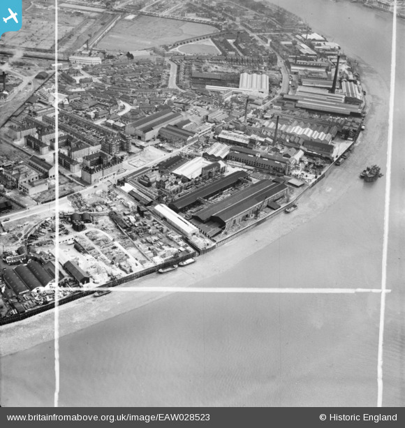
EAW028523 ENGLAND (1950). The Napier Yard and environs, Millwall, 1950. This image was marked by Aerofilms Ltd for photo editing.
© Copyright OpenStreetMap contributors and licensed by the OpenStreetMap Foundation. 2026. Cartography is licensed as CC BY-SA.
Nearby Images (11)
EAW028523

EAW028528

EAW028524

EAW028526

EAW028521

EAW028529

EAW028525

EAW028522

EAW028527

EAW021719

EPW025712

Details
| Title | [EAW028523] The Napier Yard and environs, Millwall, 1950. This image was marked by Aerofilms Ltd for photo editing. |
| Reference | EAW028523 |
| Date | 5-April-1950 |
| Link | |
| Place name | MILLWALL |
| Parish | |
| District | |
| Country | ENGLAND |
| Easting / Northing | 537440, 178463 |
| Longitude / Latitude | -0.020205738692703, 51.487906241107 |
| National Grid Reference | TQ374785 |
Pins

Matt Aldred edob.mattaldred.com |
Sunday 17th of November 2024 12:19:07 PM | |

Grollo |
Monday 14th of November 2022 04:14:35 PM | |
|
rivermersey |
Sunday 11th of August 2019 12:37:02 PM | |
|
The Laird |
Saturday 15th of June 2019 10:03:04 PM | |
|
The Laird |
Saturday 15th of June 2019 09:35:33 PM | |
|
jrussill |
Wednesday 26th of April 2017 02:02:32 PM | |
|
Grollo |
Thursday 6th of March 2014 11:33:17 PM | |
|
Grollo |
Thursday 6th of March 2014 11:31:48 PM |
User Comment Contributions
Mudchute HAA Battery |
jrussill |
Wednesday 26th of April 2017 02:03:29 PM |