
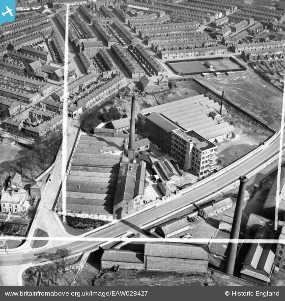
EAW028427 ENGLAND (1950). Witton Mill and Stancliffe Mill, Blackburn, 1950. This image was marked by Aerofilms Ltd for photo editing.
© Copyright OpenStreetMap contributors and licensed by the OpenStreetMap Foundation. 2026. Cartography is licensed as CC BY-SA.
Nearby Images (10)
EAW028427

EAW028424

EAW028425

EAW028421

EAW028420

EAW028423

EPW013923

EAW028422

EAW028426

EAW028419

Details
| Title | [EAW028427] Witton Mill and Stancliffe Mill, Blackburn, 1950. This image was marked by Aerofilms Ltd for photo editing. |
| Reference | EAW028427 |
| Date | 24-March-1950 |
| Link | |
| Place name | BLACKBURN |
| Parish | |
| District | |
| Country | ENGLAND |
| Easting / Northing | 367038, 427102 |
| Longitude / Latitude | -2.4997860969249, 53.739037505423 |
| National Grid Reference | SD670271 |
Pins

totoro |
Friday 25th of July 2014 08:45:10 PM | |
|
totoro |
Friday 25th of July 2014 08:40:14 PM | |
|
totoro |
Friday 25th of July 2014 08:36:36 PM | |
|
totoro |
Friday 25th of July 2014 08:35:07 PM | |
|
totoro |
Friday 25th of July 2014 08:33:55 PM | |
|
totoro |
Friday 25th of July 2014 08:30:10 PM |