
EAW026778 ENGLAND (1949). Part of the Shell Haven Oil Refinery under construction, Corringham, 1949

© Copyright OpenStreetMap contributors and licensed by the OpenStreetMap Foundation. 2026. Cartography is licensed as CC BY-SA.
Nearby Images (33)
EAW026778

EAW026779

EAW026777

EAW027729

EAW026780

EAW031736

EAW034253

EAW027716

EAW027735

EAW034246

EAW034252

EAW027726

EAW027722

EAW031739

EAW031738

EAW031737

EAW027730

EAW034251

EAW034249

EAW027731

EAW029135

EAW031733

EAW031735

EAW034247

EAW031731

EAW034250

EAW034248

EAW031734

EAW034254

EAW031732

EAW029136

EAW027733

EAW027732

Details
| Title | [EAW026778] Part of the Shell Haven Oil Refinery under construction, Corringham, 1949 |
| Reference | EAW026778 |
| Date | 3-October-1949 |
| Link | |
| Place name | CORRINGHAM |
| Parish | |
| District | |
| Country | ENGLAND |
| Easting / Northing | 571742, 181442 |
| Longitude / Latitude | 0.47491129011614, 51.505292963851 |
| National Grid Reference | TQ717814 |
Pins

cptpies |
Thursday 17th of December 2015 03:44:20 PM |
User Comment Contributions
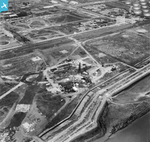
Type 24 on the seawall at the Shell Haven refinery. |
cptpies |
Thursday 17th of December 2015 03:45:31 PM |