
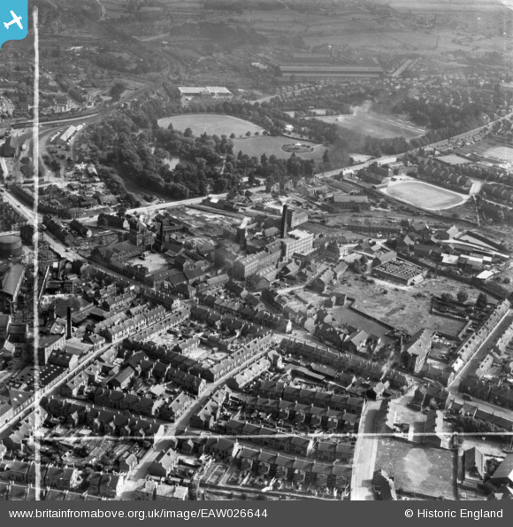
EAW026644 ENGLAND (1949). Chatsworth Road, Wheatbridge Mills, Queen's Park and environs, Chesterfield, 1949. This image has been produced from a print marked by Aerofilms Ltd for photo editing.
© Copyright OpenStreetMap contributors and licensed by the OpenStreetMap Foundation. 2026. Cartography is licensed as CC BY-SA.
Nearby Images (6)
EAW026644

EAW026645

EAW026648

EAW026647
 and environs, Chesterfield, 1949. This image has been produced from a damaged negative.")
EAW026646

EAW026642

Details
| Title | [EAW026644] Chatsworth Road, Wheatbridge Mills, Queen's Park and environs, Chesterfield, 1949. This image has been produced from a print marked by Aerofilms Ltd for photo editing. |
| Reference | EAW026644 |
| Date | 19-September-1949 |
| Link | |
| Place name | CHESTERFIELD |
| Parish | |
| District | |
| Country | ENGLAND |
| Easting / Northing | 437515, 370982 |
| Longitude / Latitude | -1.4378918603639, 53.23426461473 |
| National Grid Reference | SK375710 |
Pins

Starman |
Monday 26th of August 2024 06:36:24 PM | |
dd1000 |
Friday 19th of July 2019 02:03:11 PM | |
|
dd1000 |
Friday 19th of July 2019 01:41:57 PM | |
|
Davvo |
Tuesday 11th of September 2018 01:51:59 PM | |
|
mannidaze |
Friday 2nd of January 2015 09:21:54 PM |