
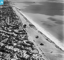
EAW025897 ENGLAND (1949). The seafront looking towards Walton Pier, Frinton-On-Sea, from the south-west, 1949

© Copyright OpenStreetMap contributors and licensed by the OpenStreetMap Foundation. 2026. Cartography is licensed as CC BY-SA.
Nearby Images (9)
EAW025897

EPW041406

EPW011634

EPW041405

EPW011635

EAW054838

EPW011633

EAW025896

EPW011636

Details
| Title | [EAW025897] The seafront looking towards Walton Pier, Frinton-On-Sea, from the south-west, 1949 |
| Reference | EAW025897 |
| Date | 10-August-1949 |
| Link | |
| Place name | FRINTON-ON-SEA |
| Parish | FRINTON AND WALTON |
| District | |
| Country | ENGLAND |
| Easting / Northing | 623608, 219243 |
| Longitude / Latitude | 1.2453859927245, 51.826532039719 |
| National Grid Reference | TM236192 |
Pins

redmist |
Sunday 18th of December 2022 08:49:58 PM | |

Matt Aldred edob.mattaldred.com |
Tuesday 1st of December 2020 08:31:43 PM | |
|
Matt Aldred edob.mattaldred.com |
Tuesday 1st of December 2020 08:31:27 PM | |
|
cptpies |
Friday 23rd of October 2015 12:35:01 PM |
User Comment Contributions
Anti Tank Blocks, Frinton-on-Sea |
cptpies |
Friday 23rd of October 2015 12:36:27 PM |