
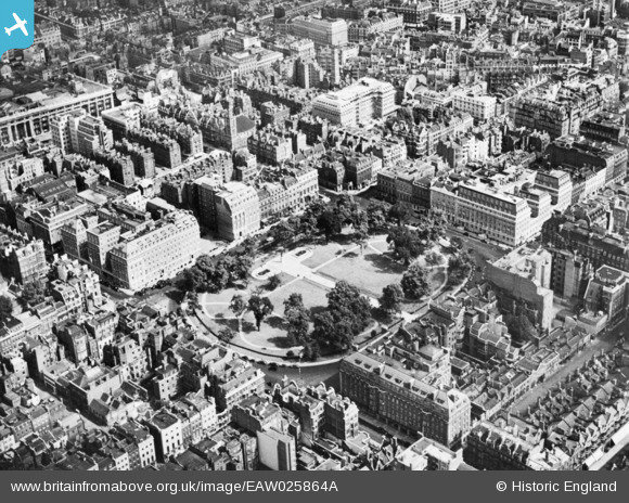
EAW025864A ENGLAND (1949). Grosvenor Square (extract from negative A25864), Mayfair, 1949. This image has been produced from a copy-negative.
© Copyright OpenStreetMap contributors and licensed by the OpenStreetMap Foundation. 2026. Cartography is licensed as CC BY-SA.
Nearby Images (20)
EAW025864A
, Mayfair, 1949. This image has been produced from a copy-negative.")
EAW042622

EAW042625

EAW042621

EAW042623

EAW025864

EAW042624

EPW045399

EPW060755

EPW059412

EPW046648

EAW050839

EPW021935

EAW021409

EPW045400

EAW021410

EPW021936

EPW021970

EAW050867

EAW050837

Details
| Title | [EAW025864A] Grosvenor Square (extract from negative A25864), Mayfair, 1949. This image has been produced from a copy-negative. |
| Reference | EAW025864A |
| Date | 5-August-1949 |
| Link | |
| Place name | MAYFAIR |
| Parish | |
| District | |
| Country | ENGLAND |
| Easting / Northing | 528389, 180848 |
| Longitude / Latitude | -0.14963969621296, 51.511470027726 |
| National Grid Reference | TQ284808 |
Pins
Be the first to add a comment to this image!
User Comment Contributions

Grosvenor Square Gardens |

Alan McFaden |
Thursday 27th of November 2014 10:48:46 PM |
Grosvenor Square |
Alan McFaden |
Thursday 27th of November 2014 10:47:57 PM |