
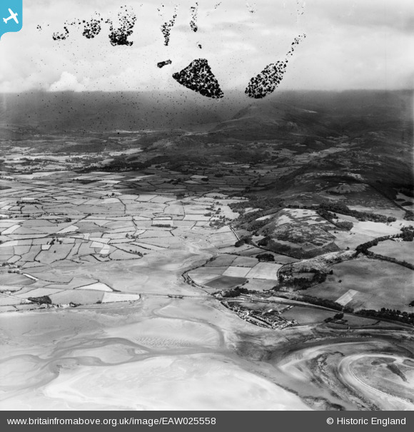
EAW025558 ENGLAND (1949). The mouth of the River Mite looking towards Wast Water, Ravenglass, from the south-west, 1949. This image has been produced from a damaged negative.
© Copyright OpenStreetMap contributors and licensed by the OpenStreetMap Foundation. 2026. Cartography is licensed as CC BY-SA.
Nearby Images (2)
EAW025558

EAW025557

Details
| Title | [EAW025558] The mouth of the River Mite looking towards Wast Water, Ravenglass, from the south-west, 1949. This image has been produced from a damaged negative. |
| Reference | EAW025558 |
| Date | 3-August-1949 |
| Link | |
| Place name | RAVENGLASS |
| Parish | MUNCASTER |
| District | |
| Country | ENGLAND |
| Easting / Northing | 308580, 496726 |
| Longitude / Latitude | -3.4069391208212, 54.35770446966 |
| National Grid Reference | SD086967 |
Pins

Ebdon |
Tuesday 26th of May 2020 12:50:39 AM | |
|
Graham Yaxley |
Thursday 12th of February 2015 05:32:46 PM | |
|
Graham Yaxley |
Thursday 12th of February 2015 05:31:13 PM | |
|
Graham Yaxley |
Thursday 12th of February 2015 05:26:53 PM | |
|
Graham Yaxley |
Thursday 12th of February 2015 05:25:45 PM | |
|
Graham Yaxley |
Thursday 12th of February 2015 05:24:45 PM | |
|
Graham Yaxley |
Thursday 12th of February 2015 05:23:24 PM | |
|
Graham Yaxley |
Thursday 12th of February 2015 05:16:16 PM | |
|
Graham Yaxley |
Thursday 12th of February 2015 05:07:27 PM | |
sirdouglas |
Thursday 10th of April 2014 10:00:12 AM | |
This is a road. I have marked the actual course of the railway |
Graham Yaxley |
Thursday 12th of February 2015 05:21:53 PM |
|
sirdouglas |
Thursday 10th of April 2014 09:59:05 AM | |
The railway stations are about 200-300 metres to NNw where I have marked them |
Graham Yaxley |
Thursday 12th of February 2015 05:19:14 PM |