
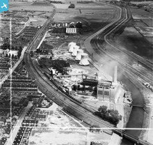
EAW023942 ENGLAND (1949). Spa Road Power Station, Lincoln, 1949. This image was marked by Aerofilms Ltd for photo editing.

© Copyright OpenStreetMap contributors and licensed by the OpenStreetMap Foundation. 2026. Cartography is licensed as CC BY-SA.
Nearby Images (10)
EAW023942

EAW023946

EAW023939

EAW023945

EAW023938

EAW023947

EAW023941

EAW023944

EAW023943

EAW023940

Details
| Title | [EAW023942] Spa Road Power Station, Lincoln, 1949. This image was marked by Aerofilms Ltd for photo editing. |
| Reference | EAW023942 |
| Date | 20-June-1949 |
| Link | |
| Place name | LINCOLN |
| Parish | |
| District | |
| Country | ENGLAND |
| Easting / Northing | 498734, 371115 |
| Longitude / Latitude | -0.52080324816228, 53.227606924408 |
| National Grid Reference | SK987711 |
Pins

Matt Aldred edob.mattaldred.com |
Tuesday 18th of March 2025 12:30:03 PM | |

Ian |
Friday 7th of March 2014 01:20:46 PM | |
|
Ian |
Friday 7th of March 2014 01:17:59 PM | |
|
Ian |
Friday 7th of March 2014 12:49:43 PM | |
|
Ian |
Friday 7th of March 2014 12:38:34 PM | |
|
Ian |
Friday 7th of March 2014 12:22:19 PM | |
|
Ian |
Friday 7th of March 2014 12:21:42 PM | |
|
Ian |
Friday 7th of March 2014 12:12:32 PM | |
|
Ian |
Friday 7th of March 2014 12:10:36 PM | |
|
Ian |
Friday 7th of March 2014 12:10:35 PM | |
|
Ian |
Friday 7th of March 2014 12:09:09 PM | |
|
Ian |
Friday 7th of March 2014 12:05:19 PM | |
|
Ian |
Friday 7th of March 2014 12:00:15 PM | |
|
Ian |
Friday 7th of March 2014 11:52:50 AM |
User Comment Contributions
Spa Road Power Station |
It's About Lincoln |
Friday 27th of December 2013 01:26:37 AM |