
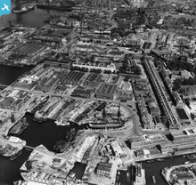
EAW023268 ENGLAND (1949). HMS Victory at Portsmouth Historic Dockyard and environs, Portsmouth, 1949. This image has been produced from a print.

© Copyright OpenStreetMap contributors and licensed by the OpenStreetMap Foundation. 2026. Cartography is licensed as CC BY-SA.
Nearby Images (4)
EAW023268

EAW648528

EAW035216

EAW035210

Details
| Title | [EAW023268] HMS Victory at Portsmouth Historic Dockyard and environs, Portsmouth, 1949. This image has been produced from a print. |
| Reference | EAW023268 |
| Date | 19-May-1949 |
| Link | |
| Place name | PORTSMOUTH |
| Parish | |
| District | |
| Country | ENGLAND |
| Easting / Northing | 462943, 100665 |
| Longitude / Latitude | -1.1066994407658, 50.801557173707 |
| National Grid Reference | SU629007 |
Pins

Matt Aldred edob.mattaldred.com |
Tuesday 1st of December 2020 06:01:35 PM | |

rivermersey |
Monday 1st of June 2020 06:33:22 PM | |
|
elanbretta |
Tuesday 9th of February 2016 01:17:12 PM | |
Obviously |
brianbeckett |
Saturday 27th of June 2020 10:24:53 PM |
|
jrussill |
Friday 12th of December 2014 05:04:08 PM |
User Comment Contributions
WW2 pillbox |
jrussill |
Friday 12th of December 2014 05:04:44 PM |