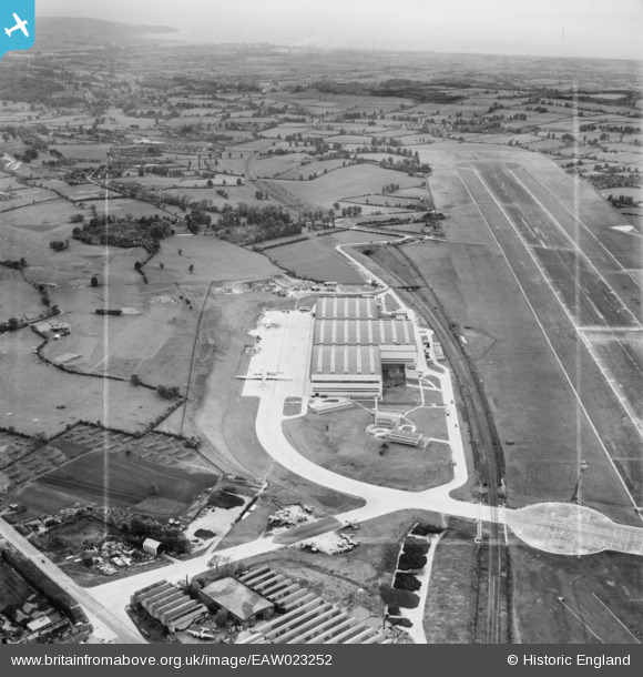
EAW023252 ENGLAND (1949). The Aircraft Assembly Hall (Brabazon Hangar) and runway at Bristol Filton Airport, Filton, from the east, 1949. This image was marked by Aerofilms Ltd for photo editing.
© Copyright OpenStreetMap contributors and licensed by the OpenStreetMap Foundation. 2026. Cartography is licensed as CC BY-SA.
Nearby Images (36)
EAW023252
 and runway at Bristol Filton Airport, Filton, from the east, 1949. This image was marked by Aerofilms Ltd for photo editing.")
EAW026958
 at Bristol Filton Airport, Bristol, from the east, 1949. This image has been produced from a damaged negative.")
EAW027401
 at Bristol Filton Airport, Bristol, from the east, 1949. This image has been produced from a damaged negative.")
EAW027400
 at Bristol Filton Airport, Bristol, 1949")
EAW019147
 at Bristol Filton Airport, Bristol, from the east, 1948. This image was marked by Aerofilms Ltd for photo editing.")
EAW023244
 and runway at Bristol Filton Airport, Filton, from the south-east, 1949. This image has been produced from a print marked by Aerofilms Ltd for photo editing.")
EAW027402
 at Bristol Filton Airport, Bristol, from the south-east, 1949. This image has been produced from a print marked by Aerofilms Ltd for photo editing.")
EAW013032
 under construction at Bristol Filton Airport, Bristol, 1948. This image has been produced from a print.")
EAW020942
 at Bristol Filton Airport, Bristol, from the south-east, 1949. This image was marked by Aerofilms Ltd for photo editing.")
EAW016124
 nearing completion at Bristol Filton Airport, Bristol, 1948. This image has been produced from a damaged negative.")
EAW027405
 at Bristol Filton Airport, Bristol, 1949. This image has been produced from a print marked by Aerofilms Ltd for photo editing.")
EAW024889
 at Bristol Filton Airport, Bristol, from the south-east, 1949")
EAW004162
 under construction at Bristol Filton Airport, Bristol, 1947")
EAW020928
 at Bristol Filton Airport, Bristol, 1949")
EAW024895
 at Bristol Filton Airport, Bristol, 1949")
EAW024896
 at Bristol Filton Airport, Bristol, 1949. This image was marked by Aerofilms Ltd for photo editing.")
EAW026955
 at Bristol Filton Airport, Bristol, from the south, 1949. This image has been produced from a print.")
EAW017483
 nearing completion at Bristol Filton Airport, Bristol, 1948")
EAW027406
 at Bristol Filton Airport, Bristol, 1949. This image has been produced from a print marked by Aerofilms Ltd for photo editing.")
EAW027403
 at Bristol Filton Airport, Bristol, 1949. This image has been produced from a print marked by Aerofilms Ltd for photo editing.")
EAW013024
 under construction at Bristol Filton Airport, Bristol, from the south-east, 1948. This image has been produced from a print.")
EAW013936
 under construction at Bristol Filton Airport, Bristol, 1948. This image has been produced from a print.")
EAW013020
 under construction at Bristol Filton Airport, Bristol, 1948. This image has been produced from a damaged negative.")
EAW020587
 at Bristol Filton Airport, Bristol, from the south-east, 1948. This image was marked by Aerofilms Ltd for photo editing.")
EAW007036
 under construction at Bristol Filton Airport, Bristol, 1947")
EAW020929
 at Bristol Filton Airport, Bristol, 1949")
EAW011962
 under construction at Bristol Filton Airport, Bristol, 1947")
EAW013031
 under construction at Bristol Filton Airport, Bristol, from the south-east, 1948. This image has been produced from a print.")
EAW020588
 at Bristol Filton Airport, Bristol, from the south-east, 1948")
EAW013932
 under construction at Bristol Filton Airport, Bristol, from the south-east, 1948. This image has been produced from a print.")
EAW019140
 at Bristol Filton Airport, Bristol, from the south-east, 1948. This image was marked by Aerofilms Ltd for photo editing.")
EAW020919
 at Bristol Filton Airport, Bristol, from the south-east, 1949. This image has been produced from a damaged negative.")
EAW020948
 at Bristol Filton Airport, Bristol, 1949")
EAW020920
 at Bristol Filton Airport, Bristol, from the south-east, 1949")
EAW017481
 nearing completion at Bristol Filton Airport, Bristol, from the south-east, 1948")
EAW004176

Details
| Title | [EAW023252] The Aircraft Assembly Hall (Brabazon Hangar) and runway at Bristol Filton Airport, Filton, from the east, 1949. This image was marked by Aerofilms Ltd for photo editing. |
| Reference | EAW023252 |
| Date | 23-May-1949 |
| Link | |
| Place name | FILTON |
| Parish | FILTON |
| District | |
| Country | ENGLAND |
| Easting / Northing | 359877, 179863 |
| Longitude / Latitude | -2.5782925424861, 51.515781697531 |
| National Grid Reference | ST599799 |
Pins

cptpies |
Thursday 9th of January 2014 12:42:54 PM |