
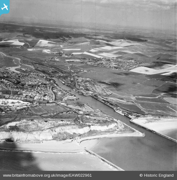
EAW022961 ENGLAND (1949). Newhaven Fort, the town and harbour, Newhaven, from the south, 1949
© Copyright OpenStreetMap contributors and licensed by the OpenStreetMap Foundation. 2026. Cartography is licensed as CC BY-SA.
Nearby Images (3)
EAW022961

EAW022962

EAW024799

Details
| Title | [EAW022961] Newhaven Fort, the town and harbour, Newhaven, from the south, 1949 |
| Reference | EAW022961 |
| Date | 6-May-1949 |
| Link | |
| Place name | NEWHAVEN |
| Parish | NEWHAVEN |
| District | |
| Country | ENGLAND |
| Easting / Northing | 544887, 100263 |
| Longitude / Latitude | 0.055535647115868, 50.783248880156 |
| National Grid Reference | TQ449003 |
Pins

redmist |
Tuesday 3rd of January 2023 03:01:01 PM | |
|
redmist |
Tuesday 3rd of January 2023 02:57:39 PM | |
|
redmist |
Monday 2nd of January 2023 08:57:08 PM | |
|
redmist |
Monday 2nd of January 2023 08:54:14 PM | |
|
redmist |
Monday 2nd of January 2023 08:49:00 PM | |
|
vandyke4ad |
Tuesday 20th of May 2014 11:22:06 AM | |
|
vandyke4ad |
Tuesday 20th of May 2014 11:17:44 AM | |
This is the "Testside", operated by James Contracting & Shipping of Southampton, later by Westminster Dredging. |
vandyke4ad |
Wednesday 21st of May 2014 03:26:24 PM |
|
vandyke4ad |
Tuesday 20th of May 2014 11:16:29 AM | |

bescotbeast |
Monday 3rd of March 2014 12:50:35 AM | |
|
bescotbeast |
Monday 3rd of March 2014 12:45:29 AM | |
Possibly the "Foremost Prince". There were usually two bucket dredgers in the harbour - a large one and a smaller one operated by a Southampton company. |
vandyke4ad |
Tuesday 20th of May 2014 11:12:44 AM |
This is the "Foremost Prince", built in 1933, which worked in Newhaven until about 1968. It then departed for Australia and New Zealand, then moved to Singapore. Its last years were spent in Yugoslavia, and was scrapped in 1985. |
vandyke4ad |
Wednesday 21st of May 2014 03:29:40 PM |
|
bescotbeast |
Wednesday 15th of January 2014 04:17:34 PM | |
|
bescotbeast |
Wednesday 15th of January 2014 04:16:47 PM | |
|
cptpies |
Monday 13th of January 2014 10:41:41 AM | |
|
cptpies |
Monday 13th of January 2014 10:41:23 AM | |
|
cptpies |
Monday 13th of January 2014 10:40:53 AM | |
|
cptpies |
Monday 13th of January 2014 10:40:30 AM | |

Alan McFaden |
Friday 27th of December 2013 04:26:45 PM | |
|
Alan McFaden |
Friday 27th of December 2013 04:26:05 PM | |
|
Alan McFaden |
Friday 27th of December 2013 04:25:29 PM |


User Comment Contributions
Newhaven Fort, CASL's and Pimples. |
cptpies |
Monday 13th of January 2014 10:43:16 AM |