
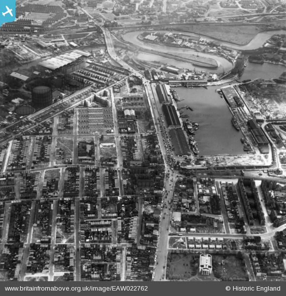
EAW022762 ENGLAND (1949). The East India Dock and environs, Blackwall, 1949. This image has been produced from a copy-negative.
© Copyright OpenStreetMap contributors and licensed by the OpenStreetMap Foundation. 2026. Cartography is licensed as CC BY-SA.
Nearby Images (10)
EAW022762

EPW046630

EPW046625

EPW046627

EPW046626

EPW046628

EPW046629

EAW022763

EPW036254

EAW099748

Details
| Title | [EAW022762] The East India Dock and environs, Blackwall, 1949. This image has been produced from a copy-negative. |
| Reference | EAW022762 |
| Date | 29-April-1949 |
| Link | |
| Place name | BLACKWALL |
| Parish | |
| District | |
| Country | ENGLAND |
| Easting / Northing | 538505, 181156 |
| Longitude / Latitude | -0.0038171652154075, 51.511848469902 |
| National Grid Reference | TQ385812 |
Pins

Grollo |
Thursday 8th of December 2022 10:20:31 PM | |
|
Grollo |
Sunday 26th of October 2014 04:32:26 AM | |
|
Grollo |
Sunday 26th of October 2014 04:30:35 AM | |
|
Grollo |
Sunday 26th of October 2014 04:24:22 AM | |
|
S00Z |
Thursday 9th of October 2014 10:55:58 AM | |
|
S00Z |
Thursday 9th of October 2014 10:54:49 AM | |
|
S00Z |
Thursday 9th of October 2014 10:53:12 AM | |
|
S00Z |
Thursday 9th of October 2014 10:52:29 AM | |
|
S00Z |
Thursday 9th of October 2014 10:51:55 AM |