
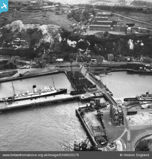
EAW020179 ENGLAND (1948). Union Street, Wellington Bridge and parts of the Western Docks, Dover, 1948. This image has been produced from a print.
© Copyright OpenStreetMap contributors and licensed by the OpenStreetMap Foundation. 2026. Cartography is licensed as CC BY-SA.
Nearby Images (19)
EAW020179

EAW020169

EAW020182

EAW020183

EAW020170

EAW020173

EAW020171

EAW020181

EAW020172

EPW000357

EAW020174

EAW020184

EAW020180

EAW007615

EAW020177

EAW020175

EAW020176

EPW019054

EAW020178

Details
| Title | [EAW020179] Union Street, Wellington Bridge and parts of the Western Docks, Dover, 1948. This image has been produced from a print. |
| Reference | EAW020179 |
| Date | 28-October-1948 |
| Link | |
| Place name | DOVER |
| Parish | DOVER |
| District | |
| Country | ENGLAND |
| Easting / Northing | 631727, 140794 |
| Longitude / Latitude | 1.3115658556338, 51.118964893357 |
| National Grid Reference | TR317408 |
Pins
Bob.59 |
Monday 23rd of September 2024 02:40:59 PM | |
|
Bob.59 |
Monday 23rd of September 2024 02:39:50 PM | |
|
Bob.59 |
Monday 23rd of September 2024 02:39:15 PM | |
|
Bob.59 |
Monday 23rd of September 2024 02:38:45 PM | |
|
Bob.59 |
Monday 23rd of September 2024 02:38:19 PM | |

mannidaze |
Friday 25th of January 2019 03:30:09 PM | |
|
cptpies |
Wednesday 1st of October 2014 12:49:29 PM |
User Comment Contributions

Emergency Coast Artillery Battery above Western Docks Dover. |
cptpies |
Wednesday 1st of October 2014 12:50:35 PM |