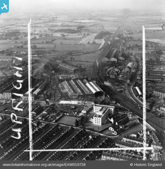
EAW019728 ENGLAND (1948). The Whessoe Engineering Works and environs, Darlington, 1948. This image has been produced from a print marked by Aerofilms Ltd for photo editing.
© Copyright OpenStreetMap contributors and licensed by the OpenStreetMap Foundation. 2026. Cartography is licensed as CC BY-SA.
Nearby Images (25)
Details
| Title | [EAW019728] The Whessoe Engineering Works and environs, Darlington, 1948. This image has been produced from a print marked by Aerofilms Ltd for photo editing. |
| Reference | EAW019728 |
| Date | 6-October-1948 |
| Link | |
| Place name | DARLINGTON |
| Parish | |
| District | |
| Country | ENGLAND |
| Easting / Northing | 428543, 516078 |
| Longitude / Latitude | -1.5587953875424, 54.539035822561 |
| National Grid Reference | NZ285161 |
Pins
Be the first to add a comment to this image!


![[EAW019728] The Whessoe Engineering Works and environs, Darlington, 1948. This image has been produced from a print marked by Aerofilms Ltd for photo editing.](http://britainfromabove.org.uk/sites/all/libraries/aerofilms-images/public/100x100/EAW/019/EAW019728.jpg)
![[EAW019727] The Whessoe Engineering Works and environs, Darlington, 1948. This image has been produced from a print marked by Aerofilms Ltd for photo editing.](http://britainfromabove.org.uk/sites/all/libraries/aerofilms-images/public/100x100/EAW/019/EAW019727.jpg)
![[EPW062183] The Whessoe Engineering Foundry, Darlington, 1939](http://britainfromabove.org.uk/sites/all/libraries/aerofilms-images/public/100x100/EPW/062/EPW062183.jpg)
![[EPW062182] The Whessoe Engineering Foundry, Darlington, 1939](http://britainfromabove.org.uk/sites/all/libraries/aerofilms-images/public/100x100/EPW/062/EPW062182.jpg)
![[EPW062173] The Whessoe Engineering Foundry and the L.N.E.R. Locomotive Works, Darlington, 1939](http://britainfromabove.org.uk/sites/all/libraries/aerofilms-images/public/100x100/EPW/062/EPW062173.jpg)
![[EPW031540] The Whessoe Foundry and the London and North Eastern Railway Locomotive Works, Darlington, 1930](http://britainfromabove.org.uk/sites/all/libraries/aerofilms-images/public/100x100/EPW/031/EPW031540.jpg)
![[EAW019726A] The Whessoe Engineering Works, Darlington, 1948. This image was modified by the Aerofilms Ltd Artists' Department and has been produced from a copy-negative.](http://britainfromabove.org.uk/sites/all/libraries/aerofilms-images/public/100x100/EAW/019/EAW019726A.jpg)
![[EPW031541] The Whessoe Foundry and the London and North Eastern Railway Locomotive Works, Darlington, 1930](http://britainfromabove.org.uk/sites/all/libraries/aerofilms-images/public/100x100/EPW/031/EPW031541.jpg)
![[EPW031543] The Whessoe Foundry and the London and North Eastern Railway Locomotive Works, Darlington, 1930](http://britainfromabove.org.uk/sites/all/libraries/aerofilms-images/public/100x100/EPW/031/EPW031543.jpg)
![[EPW031542] The Whessoe Foundry and the London and North Eastern Railway Locomotive Works, Darlington, 1930](http://britainfromabove.org.uk/sites/all/libraries/aerofilms-images/public/100x100/EPW/031/EPW031542.jpg)
![[EPW031545] The Whessoe Foundry, the Rise Carr Rolling Mills and the London and North Eastern Railway Locomotive Works, Darlington, 1930](http://britainfromabove.org.uk/sites/all/libraries/aerofilms-images/public/100x100/EPW/031/EPW031545.jpg)
![[EPW031544] The Whessoe Foundry, Brinkburn Road and the London and North Eastern Railway Locomotive Works, Darlington, 1930](http://britainfromabove.org.uk/sites/all/libraries/aerofilms-images/public/100x100/EPW/031/EPW031544.jpg)
![[EPW031539] The Whessoe Foundry and the London and North Eastern Railway Locomotive Works, Darlington, 1930. This image has been affected by flare.](http://britainfromabove.org.uk/sites/all/libraries/aerofilms-images/public/100x100/EPW/031/EPW031539.jpg)
![[EPW062184] The Whessoe Engineering Foundry, Darlington, 1939](http://britainfromabove.org.uk/sites/all/libraries/aerofilms-images/public/100x100/EPW/062/EPW062184.jpg)
![[EAW019729] The Whessoe Engineering Works and environs, Darlington, 1948. This image has been produced from a print marked by Aerofilms Ltd for photo editing.](http://britainfromabove.org.uk/sites/all/libraries/aerofilms-images/public/100x100/EAW/019/EAW019729.jpg)
![[EAW019726] The Locomotive Works, Whessoe Engineering Works and environs, Darlington, 1948. This image has been produced from a print.](http://britainfromabove.org.uk/sites/all/libraries/aerofilms-images/public/100x100/EAW/019/EAW019726.jpg)
![[EAW019720] The Whessoe Engineering Works and environs, Darlington, 1948. This image has been produced from a print.](http://britainfromabove.org.uk/sites/all/libraries/aerofilms-images/public/100x100/EAW/019/EAW019720.jpg)
![[EAW019723] The Whessoe Engineering Works and environs, Darlington, 1948. This image has been produced from a print marked by Aerofilms Ltd for photo editing.](http://britainfromabove.org.uk/sites/all/libraries/aerofilms-images/public/100x100/EAW/019/EAW019723.jpg)
![[EAW019721] The Whessoe Engineering Works and environs, Darlington, 1948. This image has been produced from a print.](http://britainfromabove.org.uk/sites/all/libraries/aerofilms-images/public/100x100/EAW/019/EAW019721.jpg)
![[EPW062179] The Whessoe Engineering Foundry, the L.N.E.R. Locomotive Works and the town, Darlington, 1939](http://britainfromabove.org.uk/sites/all/libraries/aerofilms-images/public/100x100/EPW/062/EPW062179.jpg)
![[EPW029509] Robert Stephenson and Co. Locomotive Works, Darlington, 1929](http://britainfromabove.org.uk/sites/all/libraries/aerofilms-images/public/100x100/EPW/029/EPW029509.jpg)
![[EAW019725] The Whessoe Engineering Works and environs, Darlington, from the south-east, 1948. This image has been produced from a print marked by Aerofilms Ltd for photo editing.](http://britainfromabove.org.uk/sites/all/libraries/aerofilms-images/public/100x100/EAW/019/EAW019725.jpg)
![[EAW019724] The Whessoe Engineering Works and environs, Darlington, from the south, 1948. This image has been produced from a print marked by Aerofilms Ltd for photo editing.](http://britainfromabove.org.uk/sites/all/libraries/aerofilms-images/public/100x100/EAW/019/EAW019724.jpg)
![[EAW019719] The Whessoe Engineering Works and environs, Darlington, from the south, 1948. This image was marked by Aerofilms Ltd for photo editing.](http://britainfromabove.org.uk/sites/all/libraries/aerofilms-images/public/100x100/EAW/019/EAW019719.jpg)
![[EAW019722] Sheds near the Locomotive Works, Rise Carr Rolling Mills and environs, Darlington, 1948. This image has been produced from a print.](http://britainfromabove.org.uk/sites/all/libraries/aerofilms-images/public/100x100/EAW/019/EAW019722.jpg)