
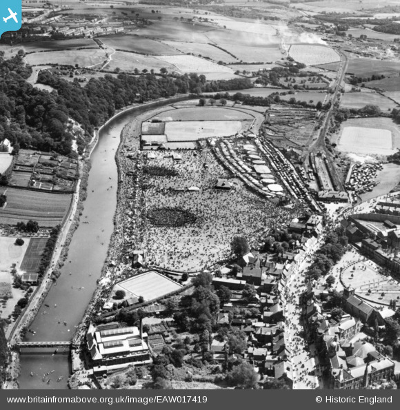
EAW017419 ENGLAND (1948). Durham, the Durham Miners' Gala at the Racecourse, 1948. This image has been produced from a print.
© Copyright OpenStreetMap contributors and licensed by the OpenStreetMap Foundation. 2026. Cartography is licensed as CC BY-SA.
Nearby Images (8)
EAW017419

EAW017413

EAW017416

EAW017418

EAW017420

EAW017417

EAW017414

EAW017415

Details
| Title | [EAW017419] Durham, the Durham Miners' Gala at the Racecourse, 1948. This image has been produced from a print. |
| Reference | EAW017419 |
| Date | 24-July-1948 |
| Link | |
| Place name | DURHAM |
| Parish | |
| District | |
| Country | ENGLAND |
| Easting / Northing | 428097, 542313 |
| Longitude / Latitude | -1.5631672557507, 54.774847008108 |
| National Grid Reference | NZ281423 |
Pins

Porcy |
Thursday 22nd of June 2017 01:40:37 PM | |
|
Porcy |
Thursday 22nd of June 2017 01:38:33 PM | |
|
Porcy |
Thursday 22nd of June 2017 01:37:37 PM | |
|
Porcy |
Thursday 22nd of June 2017 01:34:05 PM | |
|
Porcy |
Thursday 22nd of June 2017 01:30:28 PM | |
|
Porcy |
Thursday 22nd of June 2017 01:27:10 PM | |
|
Porcy |
Thursday 22nd of June 2017 01:25:15 PM | |
|
Porcy |
Thursday 22nd of June 2017 01:23:46 PM | |
|
Porcy |
Thursday 22nd of June 2017 01:21:51 PM | |
|
gBr |
Monday 9th of November 2015 09:40:10 PM | |
|
gBr |
Monday 9th of November 2015 09:32:02 PM |