
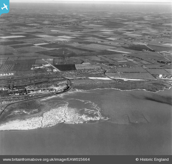
EAW015664 ENGLAND (1948). The Growths Saltings, Hay Marsh and environs, Marfleet, from the south-west, 1948. This image has been produced from a print.
© Copyright OpenStreetMap contributors and licensed by the OpenStreetMap Foundation. 2026. Cartography is licensed as CC BY-SA.
Nearby Images (3)
EAW015664

 0°
0m
0°
0m
EAW046141
 71°
203m
71°
203m
EAW004508
 38°
314m
38°
314m
Details
| Title | [EAW015664] The Growths Saltings, Hay Marsh and environs, Marfleet, from the south-west, 1948. This image has been produced from a print. |
| Reference | EAW015664 |
| Date | 18-May-1948 |
| Link | |
| Place name | MARFLEET |
| Parish | |
| District | |
| Country | ENGLAND |
| Easting / Northing | 514943, 428347 |
| Longitude / Latitude | -0.25712182386619, 53.738597905561 |
| National Grid Reference | TA149283 |
Pins
 Approx location of a recorded 2ndWW searchlight battery operating site. Approx location of a recorded 2ndWW searchlight battery operating site. |

redmist |
Friday 15th of October 2021 11:03:54 AM |
| Approx location of recorded 2ndWW pillbox. |
redmist |
Friday 15th of October 2021 11:02:39 AM |
| Approx location of a recorded 2ndWW barrage balloon operating site. |
redmist |
Friday 15th of October 2021 11:01:44 AM |
| Recorded location of a 2ndWW Z Rocket Projector anti aircraft Battery. |
redmist |
Friday 15th of October 2021 10:59:27 AM |
| Hull Angels speedway, in its first season with a D shaped track, the back "straight" being a long curve. |
gBr |
Friday 19th of July 2019 09:34:54 PM |
| Location of a WW2 pill box. |
redmist |
Friday 11th of January 2019 12:08:13 AM |
| Location of a, now removed, WW2 pill box. |
redmist |
Friday 11th of January 2019 12:05:42 AM |
| Location of a WW2 searchlight site. |
redmist |
Friday 11th of January 2019 12:04:28 AM |
| Location of the accommodation blocks serving the adjacent HAA gun sites. |
redmist |
Friday 11th of January 2019 12:03:03 AM |
 Location of the WW2 HAA Gun Battery near Preston, designation C/H4. The Defence of Britain project records - 'Mostly demolished, This unusual site has three 1938 pattern gun pits infilled but extant, the fourth has been demolished. To the north east the remains of four 5.25 inch gun pits can be seen as grass covered mounds. A magazine appears to exist in the back garden of a house and a Nissen type hut which may be original on the western side of the farm track. No sign of the command post.' Location of the WW2 HAA Gun Battery near Preston, designation C/H4. The Defence of Britain project records - 'Mostly demolished, This unusual site has three 1938 pattern gun pits infilled but extant, the fourth has been demolished. To the north east the remains of four 5.25 inch gun pits can be seen as grass covered mounds. A magazine appears to exist in the back garden of a house and a Nissen type hut which may be original on the western side of the farm track. No sign of the command post.' |
redmist |
Friday 11th of January 2019 12:01:45 AM |
| Location of the masts of a WW2 Y Station, a top secret site used for monitoring German broadcasts. The records were sent on to Bletchley Park. |
redmist |
Thursday 10th of January 2019 11:53:01 PM |