
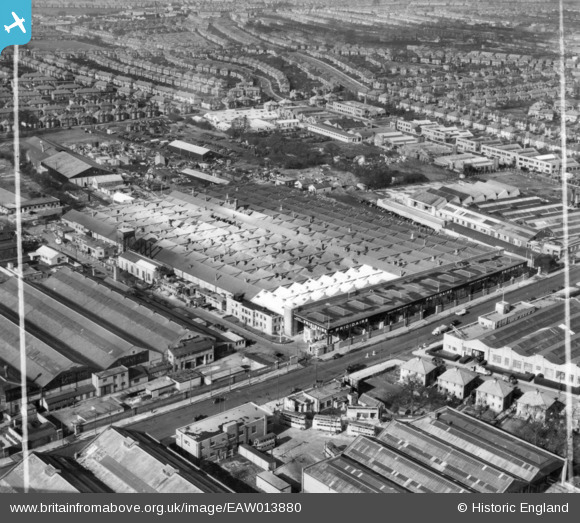
EAW013880 ENGLAND (1948). The Frigidaire Ltd Refrigerator Works and environs, Kingsbury, 1948. This image has been produced from a print marked by Aerofilms Ltd for photo editing.
© Copyright OpenStreetMap contributors and licensed by the OpenStreetMap Foundation. 2026. Cartography is licensed as CC BY-SA.
Nearby Images (38)
EAW013880

EAW013890

EAW013879

EAW013886

EAW013891

EAW013885

EAW013878

EPW019300

EPW019298

EPW019304

EPW019296

EPW019303

EPW019301

EPW019297

EAW013884

EAW013888

EAW013889

EAW013883

EAW013887

EPW019299

EAW013877

EPR000508

EPW017585

EAW051385

EAW051384

EAW051382

EPW024761

EAW044040

EPW055945

EAW044039

EPW024932

EPW055948

EAW051379

EAW051380

EAW051378

EPW012748

EAW051381

EPW013752
 on the Hyde (Edgware Road), Kingsbury, 1928. This image has been produced from a print.")
Details
| Title | [EAW013880] The Frigidaire Ltd Refrigerator Works and environs, Kingsbury, 1948. This image has been produced from a print marked by Aerofilms Ltd for photo editing. |
| Reference | EAW013880 |
| Date | 18-March-1948 |
| Link | |
| Place name | KINGSBURY |
| Parish | |
| District | |
| Country | ENGLAND |
| Easting / Northing | 520535, 189804 |
| Longitude / Latitude | -0.25970482834826, 51.593699554463 |
| National Grid Reference | TQ205898 |
Pins

Nowy Paul |
Saturday 10th of February 2018 11:30:26 AM | |

Sparky |
Thursday 27th of July 2017 10:53:33 AM | |
|
ken |
Wednesday 29th of July 2015 02:31:21 PM | |
|
ken |
Wednesday 29th of July 2015 02:30:35 PM |