
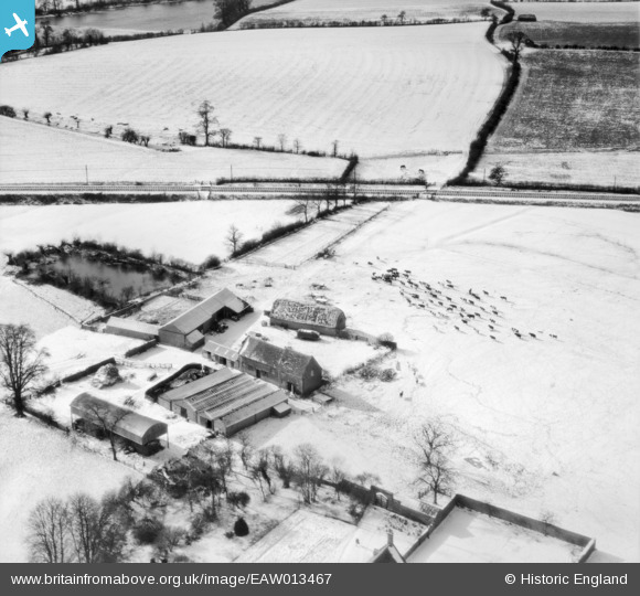
EAW013467 ENGLAND (1948). Clattercote Farm in the snow, Clattercote, 1948
© Copyright OpenStreetMap contributors and licensed by the OpenStreetMap Foundation. 2025. Cartography is licensed as CC BY-SA.
Nearby Images (2)
EAW013467

EAW013466

Details
| Title | [EAW013467] Clattercote Farm in the snow, Clattercote, 1948 |
| Reference | EAW013467 |
| Date | 20-February-1948 |
| Link | |
| Place name | CLATTERCOTE |
| Parish | CLAYDON WITH CLATTERCOT |
| District | |
| Country | ENGLAND |
| Easting / Northing | 445675, 249107 |
| Longitude / Latitude | -1.3325524963454, 52.137960725082 |
| National Grid Reference | SP457491 |
Pins
 Class31 |
Monday 4th of November 2013 09:23:15 PM |
User Comment Contributions
Thanks for the details; you may be interested to know that the original Aerofilms Ltd Register entry reads "Cattle and Farm, Warwickshire". We'll update the catalogue and post the new data here in due course. Yours, Katy Britain from Above Cataloguing Team Leader |
Katy Whitaker |
Monday 6th of January 2014 03:59:45 PM |
Looking south west |
Class31 |
Monday 4th of November 2013 09:24:19 PM |
This is Clattercote Priory Farm, just North of Banbury Credit is due to Tom Robin who located it's partner. EAW013466 |
Class31 |
Monday 4th of November 2013 09:18:57 PM |
EAW013468 is of Bourbon Tower, Stowe Park, 1948 taken on the same day. |
Class31 |
Monday 4th of November 2013 02:19:23 PM |
EAW013465 is of Compton Verney, Combrook, 1948 near Stratford on Avon |
Class31 |
Monday 4th of November 2013 02:17:37 PM |