
EAW013352 ENGLAND (1948). The Roneo Works, Romford, 1948. This image has been produced from a damaged negative.

© Copyright OpenStreetMap contributors and licensed by the OpenStreetMap Foundation. 2026. Cartography is licensed as CC BY-SA.
Nearby Images (11)
EAW013352

EPW001395

EAW013355

EAW013353

EAW013356

EAW013350

EAW013357

EAW013348

EAW013354

EAW013358

EAW013351

Details
| Title | [EAW013352] The Roneo Works, Romford, 1948. This image has been produced from a damaged negative. |
| Reference | EAW013352 |
| Date | 16-February-1948 |
| Link | |
| Place name | ROMFORD |
| Parish | |
| District | |
| Country | ENGLAND |
| Easting / Northing | 551708, 187527 |
| Longitude / Latitude | 0.18907251611429, 51.565706421489 |
| National Grid Reference | TQ517875 |
Pins

GeoffR |
Friday 16th of January 2015 04:28:09 PM |
User Comment Contributions
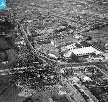
The Crown Pub still stands today. Roneo works burned down in 1969. I watched the fire as a child from my bedroom window. |
GeoffR |
Friday 16th of January 2015 04:32:00 PM |