
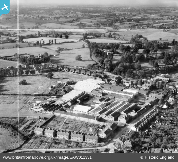
EAW011331 ENGLAND (1947). The Atlas Iron Works (Agricultural Implements), Earls Colne, from the south-east, 1947. This image was marked by Aerofilms Ltd for photo editing.
© Copyright OpenStreetMap contributors and licensed by the OpenStreetMap Foundation. 2026. Cartography is licensed as CC BY-SA.
Nearby Images (14)
EAW011331
, Earls Colne, from the south-east, 1947. This image was marked by Aerofilms Ltd for photo editing.")
EAW011332
, Earls Colne, 1947. This image was marked by Aerofilms Ltd for photo editing.")
EAW011321
, Earls Colne, 1947. This image was marked by Aerofilms Ltd for photo editing.")
EAW011329
, Earls Colne, from the south-west, 1947")
EAW011322
, Earls Colne, 1947. This image was marked by Aerofilms Ltd for photo editing.")
EAW011333
, Earls Colne, 1947. This image was marked by Aerofilms Ltd for photo editing.")
EAW011323
 and the village, Earls Colne, 1947. This image was marked by Aerofilms Ltd for photo editing.")
EAW011327
, Earls Colne, 1947. This image was marked by Aerofilms Ltd for photo editing.")
EAW043692

EAW011326
, Earls Colne, 1947. This image was marked by Aerofilms Ltd for photo editing.")
EAW011324
 and the village, Earls Colne, 1947. This image was marked by Aerofilms Ltd for photo editing.")
EAW011330
, Earls Colne, 1947. This image was marked by Aerofilms Ltd for photo editing.")
EAW011328
, Earls Colne, from the north-west, 1947. This image was marked by Aerofilms Ltd for photo editing.")
EAW011325
, Earls Colne, 1947. This image was marked by Aerofilms Ltd for photo editing.")
Details
| Title | [EAW011331] The Atlas Iron Works (Agricultural Implements), Earls Colne, from the south-east, 1947. This image was marked by Aerofilms Ltd for photo editing. |
| Reference | EAW011331 |
| Date | 1-October-1947 |
| Link | |
| Place name | EARLS COLNE |
| Parish | EARLS COLNE |
| District | |
| Country | ENGLAND |
| Easting / Northing | 585495, 228720 |
| Longitude / Latitude | 0.6980461467473, 51.925611164608 |
| National Grid Reference | TL855287 |
Pins

Matt Aldred edob.mattaldred.com |
Sunday 8th of September 2024 08:26:44 PM | |
|
Matt Aldred edob.mattaldred.com |
Sunday 8th of September 2024 08:26:38 PM | |
Ferrers |
Sunday 18th of December 2022 12:19:08 PM | |

thomasmann |
Sunday 5th of January 2014 12:15:53 AM |