
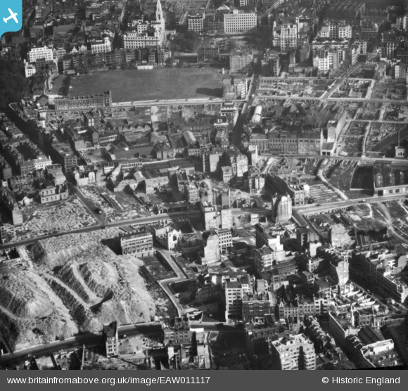
EAW011117 ENGLAND (1947). Building ruins and cleared sites following bomb damage in the Fann Street and Golden Lane area, London, 1947. This image has been produced from a print.
© Copyright OpenStreetMap contributors and licensed by the OpenStreetMap Foundation. 2026. Cartography is licensed as CC BY-SA.
Nearby Images (10)
EAW011117

EAW011201

EAW011367
, London, 1947")
EAW011202

EAW011366

EAW041392

EAW041393

EAW041390

EAW011118

EAW011216

Details
| Title | [EAW011117] Building ruins and cleared sites following bomb damage in the Fann Street and Golden Lane area, London, 1947. This image has been produced from a print. |
| Reference | EAW011117 |
| Date | 30-September-1947 |
| Link | |
| Place name | LONDON |
| Parish | |
| District | |
| Country | ENGLAND |
| Easting / Northing | 532345, 181997 |
| Longitude / Latitude | -0.092227238593661, 51.520883725556 |
| National Grid Reference | TQ323820 |
Pins

RichardWW |
Tuesday 1st of March 2022 04:41:46 PM | |
|
RichardWW |
Tuesday 1st of March 2022 04:41:23 PM | |
|
RichardWW |
Tuesday 1st of March 2022 04:40:49 PM | |
|
RichardWW |
Tuesday 1st of March 2022 04:39:29 PM | |
|
RichardWW |
Sunday 6th of February 2022 05:16:37 PM | |
|
Border Terrier |
Sunday 30th of August 2020 12:32:14 PM | |
|
Border Terrier |
Sunday 30th of August 2020 12:02:38 PM | |
|
huwbbc |
Monday 23rd of March 2015 10:07:30 PM | |
|
billyfern |
Friday 3rd of October 2014 07:12:40 PM | |
|
billyfern |
Friday 3rd of October 2014 07:12:09 PM | |
|
billyfern |
Friday 3rd of October 2014 07:11:42 PM | |
|
billyfern |
Friday 3rd of October 2014 07:09:46 PM | |
|
billyfern |
Friday 3rd of October 2014 07:08:00 PM | |
|
billyfern |
Friday 3rd of October 2014 07:07:38 PM | |
|
billyfern |
Friday 3rd of October 2014 07:07:17 PM |