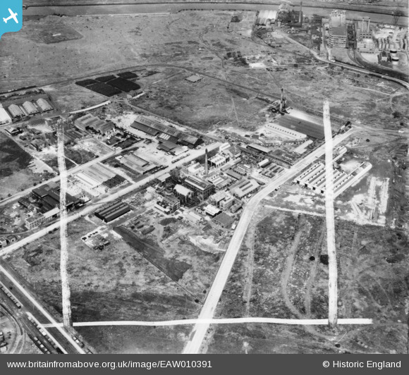
EAW010391 ENGLAND (1947). Industry at Trafford Park including the Geigy Co Ltd Works, Trafford Park, 1947. This image was marked by Aerofilms Ltd for photo editing.
© Copyright OpenStreetMap contributors and licensed by the OpenStreetMap Foundation. 2026. Cartography is licensed as CC BY-SA.
Nearby Images (19)
Details
| Title | [EAW010391] Industry at Trafford Park including the Geigy Co Ltd Works, Trafford Park, 1947. This image was marked by Aerofilms Ltd for photo editing. |
| Reference | EAW010391 |
| Date | 30-August-1947 |
| Link | |
| Place name | TRAFFORD PARK |
| Parish | |
| District | |
| Country | ENGLAND |
| Easting / Northing | 378419, 397371 |
| Longitude / Latitude | -2.32516629543, 53.472376247924 |
| National Grid Reference | SJ784974 |
Pins

redmist |
Tuesday 24th of January 2023 11:02:24 PM | |

redmist |
Tuesday 24th of January 2023 11:01:09 PM | |

redmist |
Saturday 21st of January 2023 11:21:28 PM |


![[EAW010391] Industry at Trafford Park including the Geigy Co Ltd Works, Trafford Park, 1947. This image was marked by Aerofilms Ltd for photo editing.](http://britainfromabove.org.uk/sites/all/libraries/aerofilms-images/public/100x100/EAW/010/EAW010391.jpg)
![[EAW037559] Industry at Trafford Park including the Geigy Co Ltd Works off Tenax Road, Trafford Park, 1951. This image has been produced from a print marked by Aerofilms Ltd for photo editing.](http://britainfromabove.org.uk/sites/all/libraries/aerofilms-images/public/100x100/EAW/037/EAW037559.jpg)
![[EAW037557] Industry at Trafford Park including the Geigy Co Ltd Works off Tenax Road, Trafford Park, 1951. This image has been produced from a print marked by Aerofilms Ltd for photo editing.](http://britainfromabove.org.uk/sites/all/libraries/aerofilms-images/public/100x100/EAW/037/EAW037557.jpg)
![[EAW010395] Industry at Trafford Park including the Geigy Co Ltd Works, Trafford Park, 1947. This image was marked by Aerofilms Ltd for photo editing.](http://britainfromabove.org.uk/sites/all/libraries/aerofilms-images/public/100x100/EAW/010/EAW010395.jpg)
![[EAW037560] Industry at Trafford Park including the Geigy Co Ltd Works off Tenax Road, Trafford Park, 1951. This image has been produced from a print marked by Aerofilms Ltd for photo editing.](http://britainfromabove.org.uk/sites/all/libraries/aerofilms-images/public/100x100/EAW/037/EAW037560.jpg)
![[EAW010398] Industry at Trafford Park including the Geigy Co Ltd Works, Trafford Park, 1947. This image was marked by Aerofilms Ltd for photo editing.](http://britainfromabove.org.uk/sites/all/libraries/aerofilms-images/public/100x100/EAW/010/EAW010398.jpg)
![[EAW037561] Industry at Trafford Park including the Geigy Co Ltd Works off Tenax Road, Trafford Park, 1951. This image has been produced from a print marked by Aerofilms Ltd for photo editing.](http://britainfromabove.org.uk/sites/all/libraries/aerofilms-images/public/100x100/EAW/037/EAW037561.jpg)
![[EAW037556] Industry at Trafford Park including the Geigy Co Ltd Works off Tenax Road, Trafford Park, 1951. This image has been produced from a print marked by Aerofilms Ltd for photo editing.](http://britainfromabove.org.uk/sites/all/libraries/aerofilms-images/public/100x100/EAW/037/EAW037556.jpg)
![[EAW037563] Industry at Trafford Park including the Geigy Co Ltd Works off Tenax Road, Trafford Park, 1951. This image has been produced from a print marked by Aerofilms Ltd for photo editing.](http://britainfromabove.org.uk/sites/all/libraries/aerofilms-images/public/100x100/EAW/037/EAW037563.jpg)
![[EAW010394] Industry at Trafford Park including the Geigy Co Ltd Works, Trafford Park, 1947. This image was marked by Aerofilms Ltd for photo editing.](http://britainfromabove.org.uk/sites/all/libraries/aerofilms-images/public/100x100/EAW/010/EAW010394.jpg)
![[EAW037562] Industry at Trafford Park including the Geigy Co Ltd Works off Tenax Road, Trafford Park, 1951. This image has been produced from a print marked by Aerofilms Ltd for photo editing.](http://britainfromabove.org.uk/sites/all/libraries/aerofilms-images/public/100x100/EAW/037/EAW037562.jpg)
![[EAW010393] Industry at Trafford Park including the Geigy Co Ltd Works, Trafford Park, 1947. This image was marked by Aerofilms Ltd for photo editing.](http://britainfromabove.org.uk/sites/all/libraries/aerofilms-images/public/100x100/EAW/010/EAW010393.jpg)
![[EAW037564] Industry at Trafford Park including the Geigy Co Ltd Works off Tenax Road, Trafford Park, 1951. This image has been produced from a print marked by Aerofilms Ltd for photo editing.](http://britainfromabove.org.uk/sites/all/libraries/aerofilms-images/public/100x100/EAW/037/EAW037564.jpg)
![[EAW037566] Industry at Trafford Park including the Geigy Co Ltd Works off Tenax Road, Trafford Park, 1951. This image has been produced from a print marked by Aerofilms Ltd for photo editing.](http://britainfromabove.org.uk/sites/all/libraries/aerofilms-images/public/100x100/EAW/037/EAW037566.jpg)
![[EAW010397] Industry at Trafford Park including the Geigy Co Ltd Works, Trafford Park, 1947. This image was marked by Aerofilms Ltd for photo editing.](http://britainfromabove.org.uk/sites/all/libraries/aerofilms-images/public/100x100/EAW/010/EAW010397.jpg)
![[EAW010392] Industry at Trafford Park including the Geigy Co Ltd Works, Trafford Park, 1947. This image was marked by Aerofilms Ltd for photo editing.](http://britainfromabove.org.uk/sites/all/libraries/aerofilms-images/public/100x100/EAW/010/EAW010392.jpg)
![[EAW010399] Industry at Trafford Park including the Geigy Co Ltd Works, Trafford Park, 1947. This image was marked by Aerofilms Ltd for photo editing.](http://britainfromabove.org.uk/sites/all/libraries/aerofilms-images/public/100x100/EAW/010/EAW010399.jpg)
![[EAW010396] Industry at Trafford Park including the Geigy Co Ltd Works, Trafford Park, 1947. This image was marked by Aerofilms Ltd for photo editing.](http://britainfromabove.org.uk/sites/all/libraries/aerofilms-images/public/100x100/EAW/010/EAW010396.jpg)
![[EPW034851] The Truck and Tractor Appliance Works and the Rubber Proofing Works, Trafford Park, from the east, 1931](http://britainfromabove.org.uk/sites/all/libraries/aerofilms-images/public/100x100/EPW/034/EPW034851.jpg)