
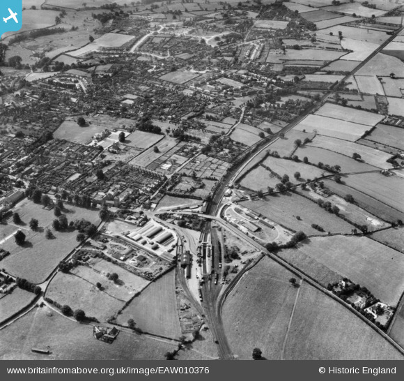
EAW010376 ENGLAND (1947). The railway station and the town, Market Drayton, from the north-east, 1947
© Copyright OpenStreetMap contributors and licensed by the OpenStreetMap Foundation. 2026. Cartography is licensed as CC BY-SA.
Nearby Images (4)
EAW010376

EAW010380

EAW010381

EAW010383

Details
| Title | [EAW010376] The railway station and the town, Market Drayton, from the north-east, 1947 |
| Reference | EAW010376 |
| Date | 30-August-1947 |
| Link | |
| Place name | MARKET DRAYTON |
| Parish | MARKET DRAYTON |
| District | |
| Country | ENGLAND |
| Easting / Northing | 367220, 334769 |
| Longitude / Latitude | -2.4874737583406, 52.90903111555 |
| National Grid Reference | SJ672348 |
Pins

Benny boy |
Friday 21st of November 2014 12:06:19 AM | |
|
Benny boy |
Wednesday 5th of November 2014 07:12:42 PM | |
|
SPARKY |
Monday 14th of April 2014 07:50:41 PM | |
|
MB |
Thursday 21st of November 2013 07:39:13 PM | |
|
MB |
Thursday 21st of November 2013 07:37:47 PM | |
|
MB |
Thursday 21st of November 2013 07:35:28 PM | |
|
MB |
Thursday 21st of November 2013 07:34:42 PM | |
|
MB |
Thursday 21st of November 2013 07:33:12 PM | |
|
MB |
Thursday 21st of November 2013 07:32:40 PM | |
|
MB |
Thursday 21st of November 2013 07:31:42 PM | |
|
MB |
Thursday 21st of November 2013 07:30:40 PM | |
|
MB |
Thursday 21st of November 2013 07:27:10 PM | |
|
MB |
Thursday 21st of November 2013 07:26:41 PM | |
|
MB |
Thursday 21st of November 2013 07:25:45 PM |