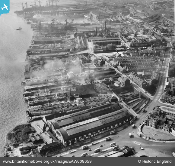
EAW008659 ENGLAND (1947). Woodside Station, the Grayson, Rollo and Clover Docks and environs, Birkenhead, 1947
© Copyright OpenStreetMap contributors and licensed by the OpenStreetMap Foundation. 2026. Cartography is licensed as CC BY-SA.
Nearby Images (33)
Details
| Title | [EAW008659] Woodside Station, the Grayson, Rollo and Clover Docks and environs, Birkenhead, 1947 |
| Reference | EAW008659 |
| Date | 1-August-1947 |
| Link | |
| Place name | BIRKENHEAD |
| Parish | |
| District | |
| Country | ENGLAND |
| Easting / Northing | 332886, 388932 |
| Longitude / Latitude | -3.0093470954068, 53.39268956076 |
| National Grid Reference | SJ329889 |
Pins

Toby Clempson |
Friday 20th of June 2014 10:11:26 AM |


![[EAW008659] Woodside Station, the Grayson, Rollo and Clover Docks and environs, Birkenhead, 1947](http://britainfromabove.org.uk/sites/all/libraries/aerofilms-images/public/100x100/EAW/008/EAW008659.jpg)
![[EAW003741] Clover's Graving Docks and Woodside Station, Birkenhead, 1947. This image was marked by Aerofilms Ltd for photo editing.](http://britainfromabove.org.uk/sites/all/libraries/aerofilms-images/public/100x100/EAW/003/EAW003741.jpg)
![[EAW003742] Clover's Graving Docks and Hamilton Square, Birkenhead, 1947](http://britainfromabove.org.uk/sites/all/libraries/aerofilms-images/public/100x100/EAW/003/EAW003742.jpg)
![[EAW008561] Clover's Graving Docks, Birkenhead, 1947. This image was marked by Aerofilms Ltd for photo editing.](http://britainfromabove.org.uk/sites/all/libraries/aerofilms-images/public/100x100/EAW/008/EAW008561.jpg)
![[EAW000411] Hamilton Square, Woodside Station and the Grayson, Rollo and Clover Docks, Birkenhead, 1946](http://britainfromabove.org.uk/sites/all/libraries/aerofilms-images/public/100x100/EAW/000/EAW000411.jpg)
![[EAW000416] Woodside Station and the Grayson, Rollo and Clover Docks, Birkenhead, 1946](http://britainfromabove.org.uk/sites/all/libraries/aerofilms-images/public/100x100/EAW/000/EAW000416.jpg)
![[EAW008664] The Grayson, Rollo and Clover Docks and environs, Birkenhead, 1947](http://britainfromabove.org.uk/sites/all/libraries/aerofilms-images/public/100x100/EAW/008/EAW008664.jpg)
![[EAW008665] The Grayson, Rollo and Clover Docks and environs, Birkenhead, 1947](http://britainfromabove.org.uk/sites/all/libraries/aerofilms-images/public/100x100/EAW/008/EAW008665.jpg)
![[EAW008563] Clover's Graving Docks, Birkenhead, 1947](http://britainfromabove.org.uk/sites/all/libraries/aerofilms-images/public/100x100/EAW/008/EAW008563.jpg)
![[EAW001719] Clover's Graving Docks, Hamilton Square, Woodside Station and environs, Birkenhead, 1946](http://britainfromabove.org.uk/sites/all/libraries/aerofilms-images/public/100x100/EAW/001/EAW001719.jpg)
![[EAW008660] The Grayson, Rollo and Clover Docks and environs, Birkenhead, 1947](http://britainfromabove.org.uk/sites/all/libraries/aerofilms-images/public/100x100/EAW/008/EAW008660.jpg)
![[EAW008564] Clover's Graving Docks and Woodside Station, Birkenhead, 1947](http://britainfromabove.org.uk/sites/all/libraries/aerofilms-images/public/100x100/EAW/008/EAW008564.jpg)
![[EAW008718] The Grayson, Rollo and Clover Docks and environs, Birkenhead, 1947](http://britainfromabove.org.uk/sites/all/libraries/aerofilms-images/public/100x100/EAW/008/EAW008718.jpg)
![[EAW008560] Woodside Station and Clover's Graving Docks, Birkenhead, 1947](http://britainfromabove.org.uk/sites/all/libraries/aerofilms-images/public/100x100/EAW/008/EAW008560.jpg)
![[EAW008719] The Grayson, Rollo and Clover Docks and environs, Birkenhead, 1947](http://britainfromabove.org.uk/sites/all/libraries/aerofilms-images/public/100x100/EAW/008/EAW008719.jpg)
![[EAW008657] The Grayson, Rollo and Clover Docks, Birkenhead, 1947](http://britainfromabove.org.uk/sites/all/libraries/aerofilms-images/public/100x100/EAW/008/EAW008657.jpg)
![[EAW008663] The Grayson, Rollo and Clover Docks, Birkenhead, 1947](http://britainfromabove.org.uk/sites/all/libraries/aerofilms-images/public/100x100/EAW/008/EAW008663.jpg)
![[EAW008662] The Grayson, Rollo and Clover Docks and environs, Birkenhead, 1947](http://britainfromabove.org.uk/sites/all/libraries/aerofilms-images/public/100x100/EAW/008/EAW008662.jpg)
![[EAW008666] The Grayson, Rollo and Clover Docks, Birkenhead, 1947](http://britainfromabove.org.uk/sites/all/libraries/aerofilms-images/public/100x100/EAW/008/EAW008666.jpg)
![[EAW008658] The Grayson, Rollo and Clover Docks and environs, Birkenhead, from the south-east, 1947](http://britainfromabove.org.uk/sites/all/libraries/aerofilms-images/public/100x100/EAW/008/EAW008658.jpg)
![[EAW000415] Woodside Station and the Grayson, Rollo and Clover Docks, Birkenhead, 1946](http://britainfromabove.org.uk/sites/all/libraries/aerofilms-images/public/100x100/EAW/000/EAW000415.jpg)
![[EAW008565] Clover's Graving Docks, Birkenhead, 1947. This image was marked by Aerofilms Ltd for photo editing.](http://britainfromabove.org.uk/sites/all/libraries/aerofilms-images/public/100x100/EAW/008/EAW008565.jpg)
![[EAW000413] Hamilton Square, Woodside Station and the Grayson, Rollo and Clover Docks, Birkenhead, 1946](http://britainfromabove.org.uk/sites/all/libraries/aerofilms-images/public/100x100/EAW/000/EAW000413.jpg)
![[EAW000410] Woodside Station and the Grayson, Rollo and Clover Docks, Birkenhead, 1946](http://britainfromabove.org.uk/sites/all/libraries/aerofilms-images/public/100x100/EAW/000/EAW000410.jpg)
![[EAW008562] Woodside Station and Clover's Graving Docks, Birkenhead, 1947. This image was marked by Aerofilms Ltd for photo editing.](http://britainfromabove.org.uk/sites/all/libraries/aerofilms-images/public/100x100/EAW/008/EAW008562.jpg)
![[EAW008661] The Grayson, Rollo and Clover Docks and environs, Birkenhead, 1947](http://britainfromabove.org.uk/sites/all/libraries/aerofilms-images/public/100x100/EAW/008/EAW008661.jpg)
![[EAW003746] Woodside Ferry, Woodside Station and Clover's Graving Docks, Birkenhead, 1947. This image was marked by Aerofilms Ltd for photo editing.](http://britainfromabove.org.uk/sites/all/libraries/aerofilms-images/public/100x100/EAW/003/EAW003746.jpg)
![[EAW003744] Clover's Graving Docks and Woodside Station, Birkenhead, 1947. This image was marked by Aerofilms Ltd for photo editing.](http://britainfromabove.org.uk/sites/all/libraries/aerofilms-images/public/100x100/EAW/003/EAW003744.jpg)
![[EAW000414] Woodside Station and the Grayson, Rollo and Clover Docks, Birkenhead, 1946](http://britainfromabove.org.uk/sites/all/libraries/aerofilms-images/public/100x100/EAW/000/EAW000414.jpg)
![[EAW001807] Hamilton Square, Woodside Ferry and environs, Birkenhead, 1946](http://britainfromabove.org.uk/sites/all/libraries/aerofilms-images/public/100x100/EAW/001/EAW001807.jpg)
![[EAW003745] Clover's Graving Docks and Woodside Station, Birkenhead, 1947. This image was marked by Aerofilms Ltd for photo editing.](http://britainfromabove.org.uk/sites/all/libraries/aerofilms-images/public/100x100/EAW/003/EAW003745.jpg)
![[EAW000412] Woodside Station and the Grayson, Rollo and Clover Docks, Birkenhead, 1946](http://britainfromabove.org.uk/sites/all/libraries/aerofilms-images/public/100x100/EAW/000/EAW000412.jpg)
![[EAW051421] The town and dock area around Hamilton Square, Birkenhead, 1953](http://britainfromabove.org.uk/sites/all/libraries/aerofilms-images/public/100x100/EAW/051/EAW051421.jpg)