
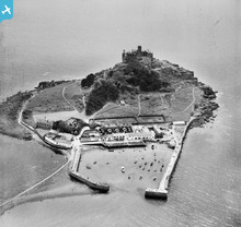
EAW007545 ENGLAND (1947). St Michael's Mount and the harbour, St Michael's Mount, 1947

© Copyright OpenStreetMap contributors and licensed by the OpenStreetMap Foundation. 2026. Cartography is licensed as CC BY-SA.
Nearby Images (34)
EAW007545

EPW059663

EAW003638

EPW059660

EAW015142

EAW005972

EPW021764

EAW003640

EAW004872

EAW007547

EAW005973

EAW003639

EAW005971

EAW007543

EPW021762

EPW021763

EAW007548

EAW004870

EAW005975

EAW007544

EAW007541

EAW005976

EAW004867

EAW005974

EAW007540

EAW007546

EPW021760

EAW007542

EAW015143

EAW004868

EAW004871

EAW033640

EAW033641

EAW004869

Details
| Title | [EAW007545] St Michael's Mount and the harbour, St Michael's Mount, 1947 |
| Reference | EAW007545 |
| Date | 25-June-1947 |
| Link | |
| Place name | ST MICHAEL'S MOUNT |
| Parish | ST. MICHAEL'S MOUNT |
| District | |
| Country | ENGLAND |
| Easting / Northing | 151481, 29987 |
| Longitude / Latitude | -5.4768572075254, 50.117220673451 |
| National Grid Reference | SW515300 |
Pins

cptpies |
Thursday 16th of January 2014 12:59:53 PM |
User Comment Contributions
Pillboxes St Michaels Mount. |
cptpies |
Thursday 16th of January 2014 01:00:36 PM |