
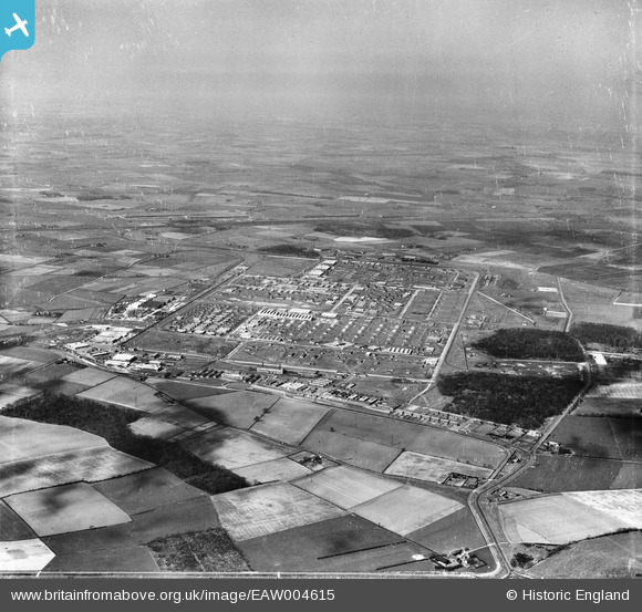
EAW004615 ENGLAND (1947). Former Royal Ordnance Factory Kirkby (Knowsley Industrial Park), Kirkby, from the south, 1947
© Copyright OpenStreetMap contributors and licensed by the OpenStreetMap Foundation. 2026. Cartography is licensed as CC BY-SA.
Nearby Images (2)
EAW004615
, Kirkby, from the south, 1947")
EAW004614
, Kirkby, from the south-west, 1947. This image was marked by Aerofilms Ltd for photo editing.")
Details
| Title | [EAW004615] Former Royal Ordnance Factory Kirkby (Knowsley Industrial Park), Kirkby, from the south, 1947 |
| Reference | EAW004615 |
| Date | 17-April-1947 |
| Link | |
| Place name | KIRKBY |
| Parish | |
| District | |
| Country | ENGLAND |
| Easting / Northing | 343179, 398012 |
| Longitude / Latitude | -2.8562072211978, 53.475513802542 |
| National Grid Reference | SJ432980 |
Pins

rich |
Monday 22nd of September 2025 10:37:15 PM | |

Matt Aldred edob.mattaldred.com |
Monday 8th of March 2021 09:26:46 PM | |
|
Matt Aldred edob.mattaldred.com |
Monday 8th of March 2021 09:26:33 PM | |
|
Matt Aldred edob.mattaldred.com |
Monday 8th of March 2021 09:26:17 PM | |
|
Matt Aldred edob.mattaldred.com |
Monday 8th of March 2021 09:26:03 PM | |
|
Matt Aldred edob.mattaldred.com |
Monday 8th of March 2021 09:25:50 PM | |
|
Matt Aldred edob.mattaldred.com |
Monday 8th of March 2021 09:25:35 PM | |
|
austin |
Thursday 4th of February 2021 08:33:07 PM | |
|
austin |
Thursday 4th of February 2021 08:29:49 PM | |
|
austin |
Thursday 4th of February 2021 08:26:21 PM | |
|
rivermersey |
Saturday 18th of April 2020 01:20:59 PM | |

Sparky |
Sunday 6th of August 2017 05:46:30 PM |