
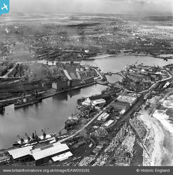
EAW003181 ENGLAND (1946). The North Eastern Marine Engineering Company Works, Sunderland Harbour and the surrounding area, Sunderland, from the east, 1946
© Copyright OpenStreetMap contributors and licensed by the OpenStreetMap Foundation. 2026. Cartography is licensed as CC BY-SA.
Nearby Images (21)
EAW003181

EAW003174

EAW003179

EPW020533

EAW003175

EPW020539

EAW003178

EAW003173

EAW003180

EAW003172

EAW003177

EAW003184

EAW001015

EPW020537

EAW003171

EPW020536

EAW003183

EAW003176

EPW051128

EAW003182

EPW020531

Details
| Title | [EAW003181] The North Eastern Marine Engineering Company Works, Sunderland Harbour and the surrounding area, Sunderland, from the east, 1946 |
| Reference | EAW003181 |
| Date | 23-October-1946 |
| Link | |
| Place name | SUNDERLAND |
| Parish | |
| District | |
| Country | ENGLAND |
| Easting / Northing | 441276, 557410 |
| Longitude / Latitude | -1.3561248912592, 54.909611368302 |
| National Grid Reference | NZ413574 |
Pins

PinzaC55 |
Thursday 18th of April 2024 01:52:24 PM | |

Matt Aldred edob.mattaldred.com |
Monday 8th of March 2021 07:04:02 PM | |
|
redmist |
Saturday 26th of September 2020 03:47:29 PM | |
|
redmist |
Friday 25th of September 2020 12:04:21 PM | |
|
redmist |
Monday 18th of March 2019 08:01:55 PM | |
|
redmist |
Monday 18th of March 2019 07:56:57 PM | |
|
redmist |
Monday 18th of March 2019 07:29:45 PM | |
|
redmist |
Monday 18th of March 2019 07:06:46 PM | |
|
redmist |
Monday 18th of March 2019 07:05:15 PM | |
|
cptpies |
Thursday 20th of December 2018 01:31:40 PM | |
|
Chris Kolonko |
Friday 15th of September 2017 09:52:55 PM | |
|
jrussill |
Tuesday 2nd of December 2014 07:51:17 PM | |
|
Peter Harrison |
Wednesday 26th of November 2014 11:18:47 AM |
User Comment Contributions

WW2 Anti Tank Blocks |
jrussill |
Tuesday 2nd of December 2014 07:51:48 PM |