
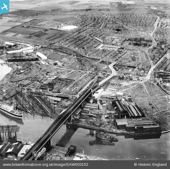
EAW003152 ENGLAND (1946). The Richardsons, Westgarth and Co Marine Engineering Works and Shipbuilding Yard (G. Clark Ltd), Queen Alexandra Bridge and the surrounding residential area, Sunderland, 1946
© Copyright OpenStreetMap contributors and licensed by the OpenStreetMap Foundation. 2026. Cartography is licensed as CC BY-SA.
Nearby Images (23)
EAW003152
, Queen Alexandra Bridge and the surrounding residential area, Sunderland, 1946")
EAW003156
 alongside Queen Alexandra Bridge, Sunderland, 1946")
EAW003159
, Sunderland, 1946")
EAW003153
, Queen Alexandra Bridge and the surrounding industrial area, Sunderland, 1946")
EAW003165
, Sunderland, 1946")
EPW006529

EAW003162
 and the surrounding industrial area, Sunderland, from the west, 1946")
EAW003150
 alongside Queen Alexandra Bridge, Sunderland, from the north-east, 1946")
EPW006528

EAW003168
 and the surrounding residential area, Sunderland, 1946")
EAW003151
 alongside Queen Alexandra Bridge, Sunderland, 1946")
EAW003161
, Glasshouse Hill and the Castletown Shipbuilding Yard, Sunderland, 1946")
EAW003167
 alongside Queen Alexandra Bridge, Sunderland, 1946")
EAW003158
 and the surrounding residential area, Sunderland, from the south-west, 1946")
EAW001035

EAW001032

EAW003169
 alongside the Queen Alexandra Bridge, Sunderland, 1946")
EAW003160
 and the Pallion Shipbuilding Yard, Sunderland, 1946")
EPW006526

EAW003163
, Sunderland, 1946")
EAW003164
, Sunderland, from the south-east, 1946")
EAW003154
, Queen Alexandra Bridge and the surrounding industrial area, Sunderland, 1946")
EAW003157
 and the Pallion Shipbuilding Yard, Sunderland, 1946")
Details
| Title | [EAW003152] The Richardsons, Westgarth and Co Marine Engineering Works and Shipbuilding Yard (G. Clark Ltd), Queen Alexandra Bridge and the surrounding residential area, Sunderland, 1946 |
| Reference | EAW003152 |
| Date | 23-October-1946 |
| Link | |
| Place name | SUNDERLAND |
| Parish | |
| District | |
| Country | ENGLAND |
| Easting / Northing | 438109, 558104 |
| Longitude / Latitude | -1.4054327423299, 54.916099930955 |
| National Grid Reference | NZ381581 |
Pins

Matt Aldred edob.mattaldred.com |
Friday 8th of March 2024 01:55:49 PM | |
|
Matt Aldred edob.mattaldred.com |
Thursday 19th of May 2022 02:11:30 PM | |

redmist |
Saturday 26th of September 2020 10:40:57 AM | |
|
redmist |
Saturday 26th of September 2020 10:39:46 AM | |
|
redmist |
Saturday 26th of September 2020 10:38:36 AM | |
|
redmist |
Saturday 26th of September 2020 10:37:41 AM | |
|
redmist |
Saturday 26th of September 2020 10:36:09 AM | |
|
redmist |
Friday 25th of October 2019 03:24:25 PM |