
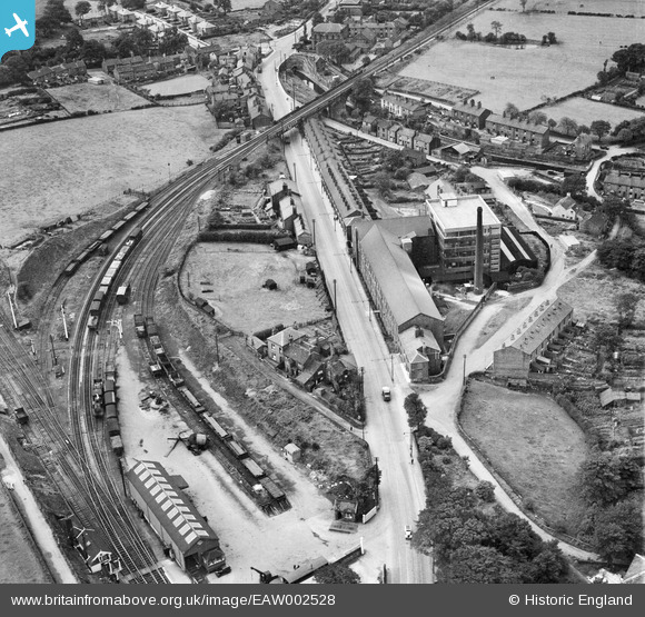
EAW002528 ENGLAND (1946). The J C Naylor & Co Ltd Emery Mills on Hyde Road and environs, Woodley, 1946
© Copyright OpenStreetMap contributors and licensed by the OpenStreetMap Foundation. 2026. Cartography is licensed as CC BY-SA.
Nearby Images (9)
EAW002528

EAW002751

EAW002531

EAW002752

EAW002527

EAW002530

EAW002529

EAW002750

EAW002753

Details
| Title | [EAW002528] The J C Naylor & Co Ltd Emery Mills on Hyde Road and environs, Woodley, 1946 |
| Reference | EAW002528 |
| Date | 10-September-1946 |
| Link | |
| Place name | WOODLEY |
| Parish | |
| District | |
| Country | ENGLAND |
| Easting / Northing | 393807, 392410 |
| Longitude / Latitude | -2.0932145343393, 53.42818515848 |
| National Grid Reference | SJ938924 |
Pins

redmist |
Thursday 3rd of January 2019 03:18:38 PM | |
|
redmist |
Thursday 3rd of January 2019 09:55:02 AM | |
|
redmist |
Thursday 3rd of January 2019 09:53:59 AM | |

Sparky |
Sunday 17th of September 2017 10:11:01 AM | |
|
Sparky |
Sunday 17th of September 2017 10:10:11 AM | |
|
Sparky |
Sunday 17th of September 2017 10:09:28 AM | |
|
Sparky |
Sunday 17th of September 2017 10:08:32 AM | |
|
totoro |
Tuesday 12th of November 2013 01:58:51 PM | |
|
totoro |
Tuesday 12th of November 2013 01:58:29 PM | |
|
totoro |
Tuesday 12th of November 2013 01:52:38 PM | |
|
totoro |
Tuesday 12th of November 2013 01:45:46 PM | |
|
totoro |
Tuesday 12th of November 2013 01:45:10 PM | |
|
Triggy |
Tuesday 12th of November 2013 01:39:35 PM | |
|
totoro |
Tuesday 12th of November 2013 01:26:45 PM | |
|
totoro |
Tuesday 12th of November 2013 01:25:40 PM | |
|
totoro |
Tuesday 12th of November 2013 01:18:29 PM | |
|
totoro |
Tuesday 12th of November 2013 01:16:50 PM | |
|
totoro |
Tuesday 12th of November 2013 01:15:43 PM |