
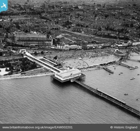
EAW002201 ENGLAND (1946). The Boating Pool, Pier Pavilion and environs, Southend-on-Sea, 1946
© Copyright OpenStreetMap contributors and licensed by the OpenStreetMap Foundation. 2026. Cartography is licensed as CC BY-SA.
Nearby Images (46)
EAW002201

EPW062738

EAW002217

EAW024662

EPW062740

EAW053089

EPW062742

EPW062739

EPW039868

EAW002199

EPW062741

EAW002218

EAW002200

EAW002202

EAW002198

EAW043703

EPW000551

EPW037015

EPW036725

EPW036705

EPW000553

EPW054672

EPW040967

EAW026906

EPW032893

EAW026899

EPW037024

EPW040975

EPW037020

EAW053074

EPW000550

EPW024892

EAW053087

EAW002205

EPW032894

EAW026907

EPW000441

EPW040978

EPW000549

EPW024896

EAW002204

EPW000448

EPW000556

EAW002203

EPW037007

EPW036723

Details
| Title | [EAW002201] The Boating Pool, Pier Pavilion and environs, Southend-on-Sea, 1946 |
| Reference | EAW002201 |
| Date | 15-August-1946 |
| Link | |
| Place name | SOUTHEND-ON-SEA |
| Parish | |
| District | |
| Country | ENGLAND |
| Easting / Northing | 588528, 185026 |
| Longitude / Latitude | 0.71844589877814, 51.532135470199 |
| National Grid Reference | TQ885850 |
Pins
Be the first to add a comment to this image!