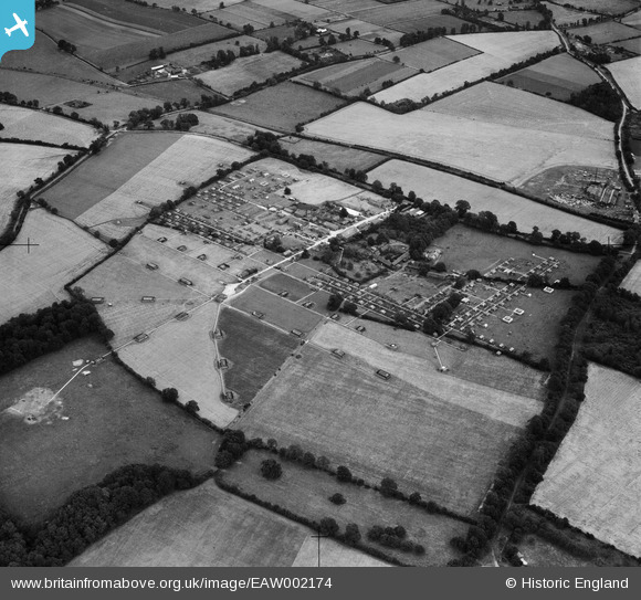
EAW002174 ENGLAND (1946). Brock's Firework Factory at Woodhall Farm, Cupid Green, 1946
© Copyright OpenStreetMap contributors and licensed by the OpenStreetMap Foundation. 2026. Cartography is licensed as CC BY-SA.
Nearby Images (14)
Details
| Title | [EAW002174] Brock's Firework Factory at Woodhall Farm, Cupid Green, 1946 |
| Reference | EAW002174 |
| Date | 15-August-1946 |
| Link | |
| Place name | CUPID GREEN |
| Parish | |
| District | |
| Country | ENGLAND |
| Easting / Northing | 507726, 209921 |
| Longitude / Latitude | -0.43835368064442, 51.777124708431 |
| National Grid Reference | TL077099 |
Pins
Be the first to add a comment to this image!


![[EAW002174] Brock's Firework Factory at Woodhall Farm, Cupid Green, 1946](http://britainfromabove.org.uk/sites/all/libraries/aerofilms-images/public/100x100/EAW/002/EAW002174.jpg)
![[EAW002178] Brock's Firework Factory at Woodhall Farm, Cupid Green, 1946](http://britainfromabove.org.uk/sites/all/libraries/aerofilms-images/public/100x100/EAW/002/EAW002178.jpg)
![[EAW002179] Brock's Firework Factory at Woodhall Farm, Cupid Green, 1946](http://britainfromabove.org.uk/sites/all/libraries/aerofilms-images/public/100x100/EAW/002/EAW002179.jpg)
![[EAW002171] Brock's Firework Factory at Woodhall Farm, Cupid Green, 1946](http://britainfromabove.org.uk/sites/all/libraries/aerofilms-images/public/100x100/EAW/002/EAW002171.jpg)
![[EAW002172] Brock's Firework Factory at Woodhall Farm, Cupid Green, 1946](http://britainfromabove.org.uk/sites/all/libraries/aerofilms-images/public/100x100/EAW/002/EAW002172.jpg)
![[EAW002173] Brock's Firework Factory at Woodhall Farm, Cupid Green, 1946](http://britainfromabove.org.uk/sites/all/libraries/aerofilms-images/public/100x100/EAW/002/EAW002173.jpg)
![[EAW002177] Brock's Firework Factory at Woodhall Farm, Cupid Green, 1946](http://britainfromabove.org.uk/sites/all/libraries/aerofilms-images/public/100x100/EAW/002/EAW002177.jpg)
![[EAW002175] Brock's Firework Factory at Woodhall Farm, Cupid Greend, 1946](http://britainfromabove.org.uk/sites/all/libraries/aerofilms-images/public/100x100/EAW/002/EAW002175.jpg)
![[EAW002176] Brock's Firework Factory at Woodhall Farm, Cupid Green, 1946](http://britainfromabove.org.uk/sites/all/libraries/aerofilms-images/public/100x100/EAW/002/EAW002176.jpg)
![[EPR000021] C. T. Brock and Co's 'Crystal Palace' Fireworks Factory and the surrounding countryside, Hemel Hempstead, 1934. This image has been produced from a damaged negative.](http://britainfromabove.org.uk/sites/all/libraries/aerofilms-images/public/100x100/EPR/000/EPR000021.jpg)
![[EPR000015] C. T. Brock and Co's 'Crystal Palace' Fireworks Factory, Hemel Hempstead, 1934](http://britainfromabove.org.uk/sites/all/libraries/aerofilms-images/public/100x100/EPR/000/EPR000015.jpg)
![[EPR000018] C. T. Brock and Co's 'Crystal Palace' Fireworks Factory, Hemel Hempstead, 1934. This image has been affected by flare.](http://britainfromabove.org.uk/sites/all/libraries/aerofilms-images/public/100x100/EPR/000/EPR000018.jpg)
![[EPR000016] C. T. Brock and Co's 'Crystal Palace' Fireworks Factory, Hemel Hempstead, 1934](http://britainfromabove.org.uk/sites/all/libraries/aerofilms-images/public/100x100/EPR/000/EPR000016.jpg)
![[EPR000017] C. T. Brock and Co's 'Crystal Palace' Fireworks Factory, Hemel Hempstead, 1934. This image has been affected by flare.](http://britainfromabove.org.uk/sites/all/libraries/aerofilms-images/public/100x100/EPR/000/EPR000017.jpg)