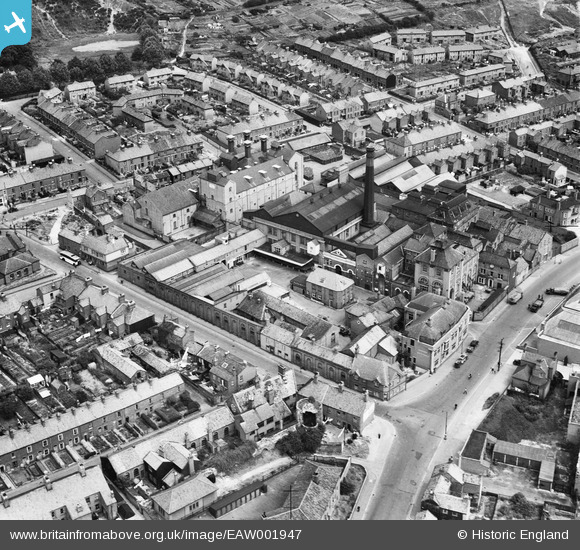
EAW001947 ENGLAND (1946). Steward and Patteson Ltd Pockthorpe Brewery, Norwich, 1946
    © Copyright OpenStreetMap contributors and licensed by the OpenStreetMap Foundation. 2025. Cartography is licensed as CC BY-SA.
  
Nearby Images (8)
Details
| Title | [EAW001947] Steward and Patteson Ltd Pockthorpe Brewery, Norwich, 1946 | 
| Reference | EAW001947 | 
| Date | 25-July-1946 | 
| Link | |
| Place name | NORWICH | 
| Parish | |
| District | |
| Country | ENGLAND | 
| Easting / Northing | 623591, 309482 | 
| Longitude / Latitude | 1.3048153620347, 52.636586421967 | 
| National Grid Reference | TG236095 | 
Pins
|  Approx location of a 2ndWW Barrage balloon operating site. |   redmist | Tuesday 23rd of November 2021 04:37:54 PM | 
|  WW2 Communal Surface Blast Shelter |   Sparky | Monday 18th of September 2017 09:37:03 PM | 
|  Mousehold Street |   Chris Lambert | Sunday 14th of June 2015 04:53:22 PM | 
|  Bull Close Road |   Chris Lambert | Sunday 14th of June 2015 04:52:24 PM | 
|  Barrack Street |   Chris Lambert | Sunday 14th of June 2015 04:51:15 PM | 
|  Silver Street |   Chris Lambert | Sunday 14th of June 2015 04:50:03 PM | 
|  Hassett Close |   Chris Lambert | Sunday 19th of April 2015 01:17:25 PM | 
|  Anchor Street |   Chris Lambert | Sunday 19th of April 2015 01:16:18 PM | 
|  Balfour Street |   Chris Lambert | Sunday 19th of April 2015 01:15:20 PM | 
|  Morley Street |   Chris Lambert | Sunday 19th of April 2015 01:14:00 PM | 
|  Silver Road |   Chris Lambert | Sunday 5th of April 2015 05:51:27 PM | 
|  Mousehold Street |   Chris Lambert | Sunday 5th of April 2015 05:50:12 PM | 
|  Harcourt Close |   Chris Lambert | Sunday 5th of April 2015 05:49:26 PM | 
 
             
  ![[EAW001947] Steward and Patteson Ltd Pockthorpe Brewery, Norwich, 1946](http://britainfromabove.org.uk/sites/all/libraries/aerofilms-images/public/100x100/EAW/001/EAW001947.jpg) 
  
                                          ![[EAW001948] Steward and Patteson Ltd Pockthorpe Brewery, Norwich, 1946](http://britainfromabove.org.uk/sites/all/libraries/aerofilms-images/public/100x100/EAW/001/EAW001948.jpg) 
 ![[EAW001949] Steward and Patteson Ltd Pockthorpe Brewery, Norwich, 1946](http://britainfromabove.org.uk/sites/all/libraries/aerofilms-images/public/100x100/EAW/001/EAW001949.jpg) 
 ![[EAW001945] Steward and Patteson Ltd Pockthorpe Brewery, Norwich, 1946](http://britainfromabove.org.uk/sites/all/libraries/aerofilms-images/public/100x100/EAW/001/EAW001945.jpg) 
 ![[EAW001943] Steward and Patteson Ltd Pockthorpe Brewery, Norwich, 1946](http://britainfromabove.org.uk/sites/all/libraries/aerofilms-images/public/100x100/EAW/001/EAW001943.jpg) 
 ![[EAW001944] Steward and Patteson Ltd Pockthorpe Brewery, Norwich, 1946](http://britainfromabove.org.uk/sites/all/libraries/aerofilms-images/public/100x100/EAW/001/EAW001944.jpg) 
 ![[EAW001946] Steward and Patteson Ltd Pockthorpe Brewery, Norwich, from the south-east, 1946](http://britainfromabove.org.uk/sites/all/libraries/aerofilms-images/public/100x100/EAW/001/EAW001946.jpg) 
 ![[EPW039226] The British Gas Light Co. Works at St Martin at Palace Plain and environs, Norwich, 1932](http://britainfromabove.org.uk/sites/all/libraries/aerofilms-images/public/100x100/EPW/039/EPW039226.jpg)