
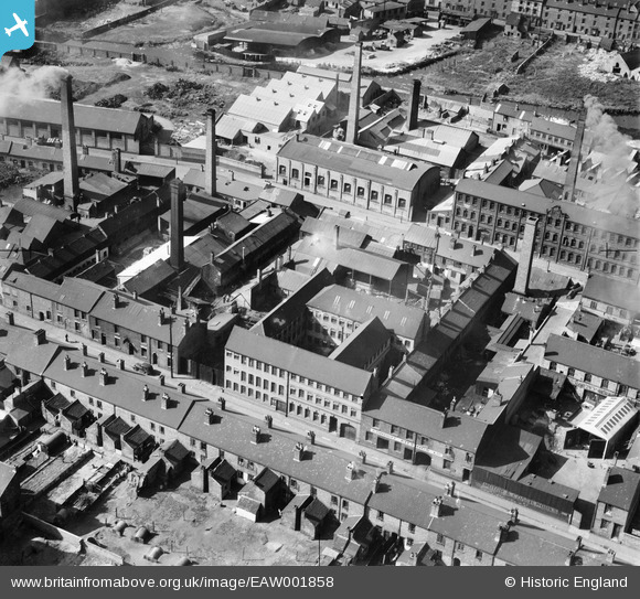
EAW001858 ENGLAND (1946). The Patterson and Stone Warehouse and the surrounding industrial area, Walsall, 1946
© Copyright OpenStreetMap contributors and licensed by the OpenStreetMap Foundation. 2026. Cartography is licensed as CC BY-SA.
Nearby Images (13)
EAW001858

EAW001859

EAW001862

EAW001861

EAW001860

EAW001854

EAW001855

EAW001857

EAW001853

EAW001856

EPW005671

EAW039989

EPW024711

Details
| Title | [EAW001858] The Patterson and Stone Warehouse and the surrounding industrial area, Walsall, 1946 |
| Reference | EAW001858 |
| Date | 12-July-1946 |
| Link | |
| Place name | WALSALL |
| Parish | |
| District | |
| Country | ENGLAND |
| Easting / Northing | 400843, 298516 |
| Longitude / Latitude | -1.9875566363861, 52.584094228566 |
| National Grid Reference | SP008985 |
Pins

Sparky |
Monday 7th of August 2017 10:08:30 PM | |

Sandwell Street Kid |
Friday 25th of April 2014 08:39:56 PM | |
|
Sandwell Street Kid |
Friday 25th of April 2014 08:37:11 PM | |
|
Sandwell Street Kid |
Friday 25th of April 2014 08:33:44 PM | |
|
Sandwell Street Kid |
Sunday 30th of March 2014 05:13:28 PM | |
|
Sandwell Street Kid |
Sunday 30th of March 2014 05:08:34 PM |
User Comment Contributions
Showing more of Frederick Street towards Navigation Street and the town. |
Sandwell Street Kid |
Sunday 30th of March 2014 05:11:29 PM |