
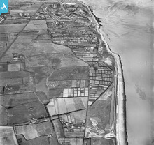
EAW001298 ENGLAND (1946). Allotments at Parkfields alongside East Hoyle Bank, Hoylake, 1946

© Copyright OpenStreetMap contributors and licensed by the OpenStreetMap Foundation. 2026. Cartography is licensed as CC BY-SA.
Nearby Images (2)
EAW001298

EAW001608

Details
| Title | [EAW001298] Allotments at Parkfields alongside East Hoyle Bank, Hoylake, 1946 |
| Reference | EAW001298 |
| Date | 24-June-1946 |
| Link | |
| Place name | HOYLAKE |
| Parish | |
| District | |
| Country | ENGLAND |
| Easting / Northing | 324606, 390989 |
| Longitude / Latitude | -3.1343388156606, 53.410060115374 |
| National Grid Reference | SJ246910 |
Pins

cptpies |
Friday 6th of December 2013 01:24:54 PM | |
This area was used as a decoy bomb site, I believe it was called the Moreton decoy,if you look opposite the two square market gardens, the control centres are showing, these are still there and are now used as stables |
davew |
Wednesday 5th of February 2014 07:42:00 PM |
User Comment Contributions
Anti Tank Blocks, Hoylake. |
cptpies |
Thursday 19th of December 2013 03:17:24 PM |